Category: Education and Training

  • Developing Tomorrow’s Leaders

    [vc_row][vc_column width=”1/1″][vc_column_text]

    The Eagle GIS Leadership Development Program 

    [/vc_column_text][us_separator size=”large”][vc_column_text]In a rapidly evolving geospatial landscape, technical excellence alone is no longer enough. Organisations need leaders who can translate spatial insight into business value, inspire highperforming teams, and guide clients and communities through complex change. The Eagle GIS Leadership Development Program was created with this purpose in mind: to intentionally develop confident, capable leaders who can shape the future of GISenabled organisations. 

    The programme supports GIS Managers and senior GIS professionals to strengthen their leadership skills. This includes GIS managers aspiring to broader management or executive roles, as well as experienced professionals preparing to move into GIS leadership positions. 

    Participants came from a wide variety of industry sectors and organisations: from central government and local government as well as from the technology, forestry, and utilities sectors. 

    Attendees have highlighted both the value of learning from experienced leaders and the opportunity to share perspectives with peers across the geospatial community: 

     “Today was a truly inspiring day. It was fantastic to share experiences and gain deeper insight into what it means to be a leader alongside a group of likeminded peers. Dena, Paul, and yourself were all inspiring presenters, covering valuable perspectives on leadership, the Geospatial Excellence Framework, and a range of practical techniques to help me better understand how I can grow as a leader—and what to avoid along the way.”– Andrew Old, Geospatial Team Leader, Ballance Agri- Nutrients. 

    “A fantastic start of Eagle Technology’s Geospatial Leadership Development Programme. Special thanks to Nathan Heazlewood for the initiative in bringing this together. Creating space for emerging and established leaders to reflect, learn, and challenge themselves is so valuable.” Nabin Paudel, Geospatial – Software Engineering Manager, Auckland Transport. [/vc_column_text][/vc_column][/vc_row][vc_row][vc_column width=”1/1″][vc_column_text]

    A Program Built for Modern GIS Leadership 

    The Eagle GIS Leadership Development Program is designed specifically for professionals working across geospatial, data, technology, and consulting environments. Recognising that many GIS leaders progress through technical pathways, the program focuses on strengthening the leadership, communication, and commercial skills needed to complement deep geospatial expertise. 

    Rather than focusing solely on generic leadership theory, Eagle grounds the program in realworld examples, geospatial scenarios, and guidance from experienced geospatial executives and leaders from New Zealand and around the world. 

    A defining feature of the program and others is that several executives and senior leaders from around the world are providing tutoring and leading discussions with the participants. For example, Paul Synnott (Managing Director of Esri Ireland) kicked off the training with a session entitled “what is leadership”.  The course participants took a lot from their discussion with Paul and said that his informal style and humour was very engaging.[/vc_column_text][us_separator][us_image image=”4407″ align=”center” link=”%7B%22url%22%3A%22%22%7D”][vc_column_text]

     Some of the course participants with Paul Synnott (virtual from Ireland) 

    [/vc_column_text][us_separator][vc_column_text]Another masterclass was provided by Izabela Miller, who is a well-known GIS leader and author of the bestselling book “The Science of GIS Leadership”. Course participants thought that her presentation was very inspiring and thought-provoking. [/vc_column_text][us_separator][us_image image=”4415″ align=”center” link=”%7B%22url%22%3A%22%22%7D”][vc_column_text]

    Izabela Miller and Nathan Heazlewood speaking at the GIS Leadership Summit in San Diego

    [/vc_column_text][us_separator][vc_column_text]Another international figure who is providing tutorship for the course is Dena Cross, Principal Consultant at Esri, who has a special interest in executive engagement. Dena has been running a similar initiative for Esri in the USA for many years, and has been a major contributor and guide to the Eagle program.

    Several more executives from around the world have led masterclasses. A graduation ceremony at the NZ Esri User Conference in Auckland in October.[/vc_column_text][/vc_column][/vc_row][vc_row][vc_column width=”1/1″][vc_column_text]

    Clear Objectives, Practical Outcomes

    The program is structured around a set of clear outcomes:

    • Develop confident leaders who can operate effectively at team, project, and organisational levels
    • Bridge the gap between technical delivery and business strategy, enabling GIS professionals to influence decision‑makers
    • Improve people leadership capability, including coaching, feedback, and performance management
    • Strengthen communication and stakeholder engagement, particularly with non‑technical audiences
    • Build sustainable leadership behaviours that scale as organisations grow

    Participants leave not just with new knowledge, but with practical tools, frameworks, and habits they can immediately apply.[/vc_column_text][/vc_column][/vc_row][vc_row][vc_column width=”1/1″][vc_column_text]

    Core Focus Areas

    Strong leadership within the Eagle GIS Leadership Development Program is defined by the integration of mindset, capability, and behaviour, all underpinned by integrity and trust. Rather than treating leadership as a single skill, the program recognises that effective leaders combine strategic thinking, sound judgment, operational discipline, and strong interpersonal behaviours to create sustainable impact in GIS-enabled organisations.

    The program covers nine interconnected capability areas:[/vc_column_text][us_separator][us_image image=”4416″ align=”center” link=”%7B%22url%22%3A%22%22%7D”][vc_column_text]

    Esri/Eagle’s Leadership Model

    [/vc_column_text][us_separator][vc_column_text]A strategic mindset allows leaders to look beyond immediate tasks and project deliverables to understand the broader organisational, client, and industry context. Leaders with this capability connect GIS capability to long-term outcomes, anticipate change, and align team efforts with strategic priorities. They are able to balance day-to-day demands while keeping sight of future opportunities and risks, ensuring that technical work contributes meaningfully to organisational direction.

    Business acumen strengthens a leader’s ability to make decisions that are commercially sound as well as technically correct. This includes understanding financial drivers, articulating value in business terms, and making informed trade-offs between scope, quality, time, and risk. For GIS leaders, business acumen supports the shift from being seen purely as technical specialists to becoming trusted advisors who understand the realities of organisational decision-making.

    Operational excellence focuses on consistent, reliable delivery while enabling continuous improvement. Leaders strong in this area establish clear processes, manage resources effectively, and maintain quality under pressure. Within the Eagle GIS context, operational excellence is enhanced by flexibility—adapting traditional delivery discipline to support modern, agile ways of working without compromising outcomes or team wellbeing.

    People management, with a strong team focus, is essential to creating environments where individuals can perform and grow. Effective leaders set clear expectations, provide coaching and feedback, and address performance issues constructively. In GIS teams, this often involves leading diverse specialists with different skills and motivations, while fostering psychological safety, inclusion, and sustained engagement.

    Leadership behaviours are equally critical. Emotional intelligence begins with self-awareness and self-management. Leaders who demonstrate emotional intelligence understand how their behaviour affects others, regulate their responses under pressure, and remain open to feedback. This self-focus enables leaders to act with professionalism, empathy, and credibility, even in challenging situations.

    Adaptability allows leaders to remain effective amid change and uncertainty. Adaptable leaders adjust their approach based on context, remain open to new ideas, and learn quickly from experience. In fast-evolving GIS and technology environments, adaptability supports resilience and helps teams navigate ambiguity with confidence.

    Communication is one of the most visible expressions of leadership. Strong communicators translate complex geospatial concepts for non-technical audiences, listen actively, and provide clarity during change. Clear, purposeful communication helps align stakeholders, reduce misunderstanding, and build confidence across teams and clients.

    Collaboration reflects a leader’s ability to work effectively across disciplines, teams, and organisations. Collaborative leaders break down silos, value diverse perspectives, and foster shared ownership of outcomes. In consulting and enterprise GIS settings, collaboration is essential to delivering integrated solutions that meet real-world needs.

    All of these skills and behaviours rest on a foundation of integrity and trust. Leaders build trust by acting consistently with values, being transparent, keeping commitments, and taking responsibility for outcomes. Integrity is what allows leadership capability to scale; without it, authority diminishes, and engagement erodes. With it, leaders create environments where people are willing to contribute their best work and follow with confidence.[/vc_column_text][us_separator][us_image image=”4425″ align=”center” link=”%7B%22url%22%3A%22%22%7D”][vc_column_text]

    Nathan Heazlewood explaining the Rangitikei District Council Strategy

    [/vc_column_text][/vc_column][/vc_row][vc_row][vc_column width=”1/1″][vc_column_text]

    Benefits for Individuals and Organisations

    For participants, the program builds clarity, confidence, and career momentum.

    For organisations, the benefits are equally compelling:

    *   Stronger leadership pipelines within GIS and data teams

    *   Improved project and client outcomes

    *   Higher employee engagement and retention

    *   Better alignment between spatial capability and organisational strategy

    By investing in leadership capability, organisations future‑proof their geospatial investments. Eagle believes that there are also benefits for the geospatial industry as a whole, through enhancing the leadership skills of one group of professionals, who will then influence the teams that they work with, and through engagement with others in the industry.[/vc_column_text][/vc_column][/vc_row][vc_row][vc_column width=”1/1″][vc_column_text]

    A Commitment to Growing the GIS Profession

    At its core, the Eagle GIS Leadership Development Program reflects a broader commitment: elevating the role of GIS professionals as trusted advisors, not just technical specialists. As spatial data becomes increasingly central to decision‑making, organisations need leaders who can navigate complexity, inspire others, and deliver meaningful impact.

    Through this program, Eagle GIS is helping shape the next generation of geospatial leaders-grounded in technical excellence, guided by strong leadership principles, and ready to lead with purpose.[/vc_column_text][us_separator][us_image image=”4427″ align=”center” link=”%7B%22url%22%3A%22%22%7D”][vc_column_text]

    The founding cohort of the Eagle GIS Leadership Program

    [/vc_column_text][/vc_column][/vc_row][vc_row][vc_column width=”1/1″][/vc_column][/vc_row]

  • How do I off board members in ArcGIS Online? Tertiary Education Institution Focus.

    How do I off board members in ArcGIS Online? Tertiary Education Institution Focus.

    Any Tertiary Education Institution that uses an ArcGIS Online subscription will need to implement a plan for managing their content and membership.

    As your education institution increasingly relies on ArcGIS Online for teaching and research mapping and geospatial needs, it’s vital to establish a robust plan to ensure efficiency, continuity and easy offboarding processes for students and staff.

    Establish a Data Governance Plan

    This robust plan is often referred to as a data governance plan for your education institutions ArcGIS Online subscription.

    What is Data Governance?

    Data governance is about setting institution-wide standards – data policies – that apply to how data is gathered, stored, accessed, processed, and disposed of.

    Why have a Data Governance Plan?

    A data governance plan for managing an ArcGIS Online subscription can help you plan for increased use of your ArcGIS Online subscription and avoid problems.

    What should be addressed in a data governance plan for an ArcGIS Online Subscription?

    • Monitoring utilisation of ArcGIS Online
    • Handling of user content when a student or staff member leaves your institution
    • Regularly informing users of your data governance plan and how it will impact them

    In developing a data governance plan for ArcGIS Online, a good starting point can be to review any existing data governance practices you might have for other systems, and mirror those. Answer questions such as “How often is data purged?”, “What happens to existing content when a user leaves?”, etc.

    Consider including in your data governance plan a statement about when content will be deleted. For example, Content will be deleted when the owner has not logged in during the last 2-years and no one has viewed the content in the last 3-years. This statement will differ between education institutions. You might want to check with your educational institutions ethics people, before adding this statement, to see what the general policy is about keeping students work.

    Monitoring utilisation of ArcGIS Online

    The ArcGIS Online Usage Reports (Organization>Status) are a good place to start. They provide easy access to total usage data. Further analysis and efforts may be needed to provide information for ongoing, repeat usage, as well as daily reporting. Check out the GIS for Everyone (…and how to build your own ArcGIS Dashboard to show it!) blog for an example of how to implement further analysis of an ArcGIS Online subscription.

    Offboarding users

    Ensure that proper messaging is in place when off-boarding members of your ArcGIS Online subscription. Proactively remind members – before they leave – about their options for transferring content, and what happens to their content after they leave.

    Some options that you might like to give your members who are leaving your subscription are:

    • Transferring their content to another member of your ArcGIS Online subscription
    • Transferring their content to an ArcGIS for Personal Use subscription
    • Transferring their content to another ArcGIS Online organisation – only applies if the person leaving your education institutions is shifting to an organisation that has an existing ArcGIS Online subscription.
    • Deleting their own content

    We encourage you to empower your users to take care of the offboarding process as much as possible.

    Some tools that are useful for offboarding members are listed below:

    • ArcGIS Assistant developed by a team from Esri Professional Services, this tool is not supported by Esri or Eagle Technology. This tool can be utilised by any member of an ArcGIS Online subscription.
    • Admin Tools for ArcGIS Online by GEO Jobe GIS Consulting. This tool can only be utilised by a user who has the role of Administrator in your ArcGIS Online subscription.

    Communication

    Members of your ArcGIS Online subscription will not implement their part of the data governance plan if they don’t know about it. Therefore, you will need to ensure that the members of your ArcGIS Online subscription are regularly reminded about the plan. So, use the different communication channels within your education institutions to widely distribute the plan amongst your users. Do not forget to include the data governance plan when onboarding new members to your ArcGIS Online subscription.

    In conclusion, a robust data governance plan is essential for managing members and content in an ArcGIS Online subscription. It helps you monitor usage and handle offboarding smoothly.

    If you need further assistance with a data governance plan for your ArcGIS Online subscription, please contact your Eagle Technology Account Manager.

  • Welcome to Instructor Assisted Learning Labs

    Welcome to Instructor Assisted Learning Labs

    In 2024 Eagle Technology will be introducing a new instructor-led training format. Read on to learn more about this format.

    Our new training format is entitled an Instructor Assisted Learning Lab. These Learning Labs offer a unique twist to traditional Instructor Led training courses.

    During a designated three-day period, typically from Tuesday to Thursday, you will have the flexibility to choose both the specific instructor-led course you wish to undertake and the days on which you prefer to complete the training. For instance, for a one-day course, you might choose to attend on a Tuesday or only in the mornings on Wednesday and Thursday (9 am – 12:30 pm). Similarly, for a two-day course, options could include completing it on Tuesday and Wednesday or Wednesday and Thursday. This training format will only be available in-person.

    Throughout the three-day period, you may find varying numbers of learners in the room, each completing a different course. Because of this, for each lesson of the course you are attending you will have a recording to listen to. These recordings have been completed with a “live audience” to make them as interactive as possible. You will have access to a virtual machine for the duration of the course to complete course activities and exercises. A knowledgeable instructor will be on hand in the room to:

    • address questions,
    • facilitate discussions on the application of course concepts, and
    • resolve technical issues.

    Catering will be provided, allowing you to network with fellow learners during break times.

    The following courses will be offered as Instructor Assisted Learning Labs:

    You will need to:

    • register via the course description
    • specify which session / days of the week you will be attending the course
    • bring your own headset to enable you to listen to course recordings without disturbing other learners in the training room.

    Please Note that Instructor Assisted Learning Labs will only be run out of the new Wellington Eagle Technology Training Room.

    Upon course completion, you will receive an electronic course completion certificate for the instructor-led course you attended.

    If you would like more information about this format or would like to register your interest in attending a course in this format, please contact gistraining@eagle.co.nz

  • Esri User Conference Experience 2023

    Esri User Conference Experience 2023

    Rachel Lawson – University of Auckland and NZ Esri Young Scholar Award Winner 2023

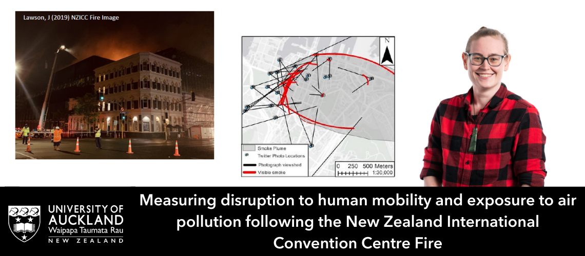
    I was fortunate enough to win this year’s New Zealand Esri Young Scholar Award for my work title “What were the impacts on human mobility during the New Zealand International Convention Centre Fire?”” completed during the Bachelor of Science Honours in Geography postgraduate studies at the University of Auckland. I set out to identify disruptions to movement corridors, exposure to smoke/air pollution, and emergency and citizen response in Auckland, New Zealand using GIS datasets and social media images. I heard about the award through my master’s supervisors, Dr Katarzyna Sila-Nowicka (Sila) and Associate Professor Daniel Exeter who recommended I put my work forward. I’d heard how amazing the conference was from previous winners and was surprised to win. I had not travelled long haul before and all my scheduled travel during my Masters and BSc(Hons) postgraduates degrees was cancelled or converted to virtual due to the pandemic, so the award and trip was especially exciting for my professional and personal development.

    During the conference I meet with other young scholars from around the world including Spain, India, Colombia, France, Sweden, and other European countries. We explored not only the user conference but also attended the education summit for two days prior to the UC, which included hands-on learning labs and workshops, presentations, and networking. As a group we also travelled to Coronado Island and other tourists’ attractions during the shorts breaks between events.

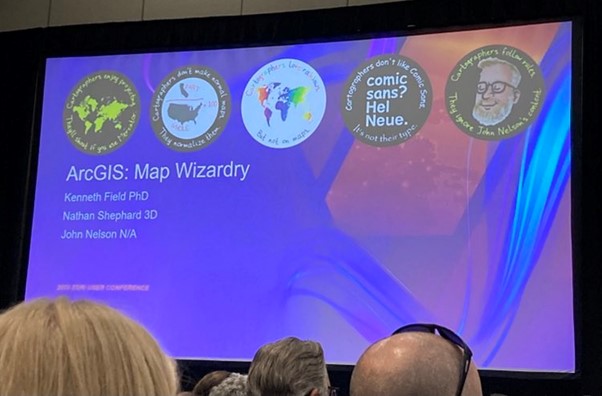
    My favourite presentation during the conference was a panel session by John Nelson, Ken Field, and Nathan Shepard titled Map Wizardry. During the presentation raw datasets were converted in exciting and visually appealing cartographic designs using basic tools in ArcGIS. It has inspired me to add more design flare to my outputs, without needing to spend too much additional time in the process. I also enjoyed the expo, and meeting/complaining to product designers, hopefully some of my suggestions influence upcoming modifications. And I’m particularly excited by upcoming changes to ArcGIS for Microsoft 365, which should increase my day-to-day productivity and enable teammates to collaborative view our projects on teams.

    During the conference I was able to attend many social events including Kiwi Night, Young Professionals Pool Party, a Baseball Game with Eagle Staff and more. In each event I was able to build new connections internationally and within New Zealand which will continue to help my work in science research now at GNS, a crown research institute.  I also enjoyed weekend break after the conference exploring the sunny San Diego Coast including a trip to the USS Midway Museum, SeaWorld theme park, San Diego Zoo, outlet shopping at the Tijuana border and a sailboat trip before returning to New Zealand winter and work.

    I owe a massive thank you to Esri, and Eagle Technology for funding my travel and award, along with the support during the travel. I thoroughly recommend any students or recent graduates take the time to share their work and apply for this award in the future.

  • Creating an Esri Academy Learning Plan

    Creating an Esri Academy Learning Plan

    Learn how to create a Learning Plan of eLearning resources within the Esri Academy site. 

    Creating a custom Learning Plan in Esri Academy can help you or your colleagues focus their learning on a particular ArcGIS topic or product.

    The process for creating a custom Learning Plan is as follows:

    1. Open the Esri Academy
    2. Sign in
    3. Once you have successfully signed in, click My Academy > My Learning Plans
    4. On the My Learning Plans page click the Create a Learning Plan button on the top right of the page
    5. Give your Plan a Title and a Description
    6. Click Create New Plan
    7. If you know the titles of the eLearning resources, you would like to add to your plan you can start typing them in the add courses text box e.g. GIS for Climate Action.
    8. Alternatively, you can add eLearning directly from the Esri catalog
      • Search for a course e.g. ArcGIS Pro Basics
      • Locate the circle with the plus button within it on the course banner heading and click
      • Select a Plan to add the course to – this should be the plan you created earlier in this process.
      • Click Add to Plan
      • Click Close
    9. Once you have added all the courses you want to, to the learning plan you can return to the My Learning Plans page to view your Learning Plan
    10. To change the order of the courses in the plan:
      • click the edit plan button under the Learning Plan name
      • hover your cursor over the four headed arrow icon in the vertical colour strip on the left of the course card
      • Click, hold and drag the course card to the correct position in the Learning Plan.
      • Release your cursor
    11. Save the plan once you have made all the reordering of courses
    12. If the learning plan is to be used by multiple people in your organisation you can assign the plan to these people.
    13. To assign the plan
      • Locate and click the Assign Plan link just under the Learning Plan title
      • Enter the email addresses of the people you would like to assign the learning plan to (separate multiple email address with a comma or a space)
      • Add a message to the person who will be receiving the assignment of the Learning Plan
      • If required, add a date of when the Learning Plan needs to be completed by
      • If necessary, preview the email and make the desired changes in your personal message.
      • Once you are happy with the content of the email click the Send Invite button.
      • A view assignments button will appear beside the Edit plan button on the learning plan once the invite has been sent.
      • The person or people you have assigned the plan too will receive an email to enrol in the plan. Until they have enrolled in the plan their status under the view assignments button will be set to Not Accepted. You can resend the invite to enrol in the Learning Plan. Once a person has enrolled in a Learning Plan their status will be set to Enrolled. As the owner of a Learning Plan you can track peoples progress in completing the Learning Plan.

    Requirements

    To be able to create a learning plan on the Esri Academy site you need to be signed in to https://www.esri.com/training/ with either a My Esri username and password or an ArcGIS Online username and password with Esri access enabled. Refer to the Accessing Esri Academy eLearning resources blog for more details.

    Exceptions

    Eagle Technology Instructor-Led courses from our course catalogue cannot currently be added to Esri Academy Learning Plans. If you have access to a private catalogue within Esri Academy eLearning resources from this catalogue are also not available to be added to an Esri Academy Learning Plan.

    Final note

    There are Esri created Learning Plans available for you to enrol in. For a list of Esri created Learning Plans visit https://www.esri.com/training/learning-plans/ and change the Plan Created by Filter to Esri Plans. Some of the Esri created Learning Plans contain links to Esri run Instructor-Led courses. If you would like to attend the equivalent Instructor Led course in New Zealand time and pay for the course in NZ dollars please visit https://www.eagle.co.nz/learn/course-catalogue to find out when the Instructor Led course is next running via Eagle Technology. If you can’t find the Instructor Led course on the Eagle schedule please contact gistraining@eagle.co.nz.

    If you would like some assistance with setting up an Esri Academy eLearning Learning Plan, please contact gistraining@eagle.co.nz.

  • New Zealand Esri Young Scholar Award 2023 – Winner

    New Zealand Esri Young Scholar Award 2023 – Winner

    The Esri Young Scholar Award is about recognising the very best GIS students around the globe. Every year, Esri’s global partners nominate at least 25 university students for excellence in relation to a GIS project. These projects include comprehensive research papers, software development, impactful maps, and apps that promote education, conservation, disaster response, and urban planning.

    As the winner of the 2023 New Zealand Esri Young Scholar Award, Rachel Lawson, recent graduate of the University of Auckland, will be winging her way to San Diego to attend the Esri Education Summit and Esri User Conference in July 2023.

    Rachel’s award-winning project “Measuring disruption to human mobility and exposure to air pollution following the New Zealand International Convention Centre Fire” identified disruptions to movement corridors, exposure to smoke / air pollution, and emergency and citizen response during and after the event in Auckland, New Zealand in 2019. The judges were particularly impressed with the innovative use of ArcGIS to map social media posts.

    At Esri User Conference 2023 Rachel will get to display her project poster in the Map Gallery, in front of thousands of worldwide ArcGIS users and to meet Jack Dangermond in person at the Special Achievement Award Ceremony.

    We will make Rachel’s poster available for you to view post Esri User Conference. Hopefully, we will also be able to hear Rachel’s reflections on the summit and conference once she returns.

    The judges would like to highly commend Dylan Pollard, from the University of Otago, as the runner up for the New Zealand Esri Young Scholar Award 2023. Dylan’s project looked at the use of GIS in pest management in West Harbour, Dunedin. As runner up to this award Dylan will receive a complimentary registration to the New Zealand Esri User Conference in Auckland 2023.

    Thank you to all the other young scholars who applied for the New Zealand Esri Young Scholar Award in 2023. Your submissions were of the highest standard and made the judge’s job in choosing the best project very difficult.

  • Accessing Esri Academy eLearning

    Accessing Esri Academy eLearning

    If you would like to learn about a workflow or a component of the ArcGIS System at your own pace, eLearning from the Esri Academy is the place for you. 

    What is the Esri Academy?

    The Esri Academy is where you can access eLearning resources, created by Esri, to help you keep up with the rapidly changing geospatial world and to build the skills and expertise you need to reach your geospatial goals.

    The Esri Academy is sometimes referred to as the Esri Training website.

    eLearning Types

    There is a plethora of types of eLearning on the Esri Academy. Each type of eLearning in defined below:

    • MOOCs – Massive, open, online courses. Esri MOOCs range in length from four to six weeks and require an investment of two-three hours of study per week. A new set of materials is released each week for you to work through. Esri MOOCs have been designed to help expand horizons and advance geospatial careers.
    • Story Maps – Story Maps referenced on the Esri Academy combine authoritative maps with narrative text, images and multimedia content to enable you to learn about a specific topic or product in the ArcGIS System.
    • Training Seminars – Live and recorded video presentations with software demonstration by Esri subject matter experts. Eagle Technology also offers Training Seminars under the guise of our GIS Webinar Series. For a list of upcoming Eagle Technology Webinars visit https://bit.ly/3iNJiq5.
    • Tutorials – tutorials provide step by step instruction on how to complete a task or learn a workflow, they tend to cover some of the newer technology that Esri has recently released. Most tutorials are under an hour in length.
    • Videos – training and educational videos from Esri and industry experts
    • Web Courses – interactive self-paced courses with activities and hands-on exercises. Web courses are more in-depth than tutorials and therefore tend to take longer to complete.

    To access all Esri Academy eLearning content visit www.esri.com/training/Bookmark/PKZLC4PPYJ

    How do you get access to all the eLearning on the Esri Academy?

    To access any of the eLearning resources on the Esri Academy you need to login. Therefore, you need to have an Esri username and password. This may be an Esri public account, or a username connected to the organisation that you work for (this may be your ArcGIS Online username). The type of account you have will determine the level of access to eLearning resources you have.

    An Esri public account only gives you access to the eLearning resources  that are marked as ‘Free’. To access eLearning resource marked with the words ‘Requires Maintenance’, you need to have a username connected to the organisation you work for. This organisation also needs to pay Esri fees via Eagle Technology to access ArcGIS products and therefore to gain access to these resources. To connect an Esri public account to your organisation you need to have a chat to your organisation’s GIS Administrator to find out who can connect your account.

    Happy learning smiley

    By the way, if you are wanting to learn via instructor-led training instead of eLearning resources and are located in New Zealand or the South Pacific please visit Eagle Technology’s learn page for a list of the instructor-led courses we offer https://www.eagle.co.nz/learn/course-catalogue

    Information for GIS Administrators

    Your organisation can give employees access to all Esri Academy resources in one of two ways:

    • Through an Esri access enabled ArcGIS Online username
    • Via an Esri public account linked to your organisation’s My Esri account

    To enable Esri access on an ArcGIS Online username follow the instructions at https://bit.ly/3QOGhlW. With Esri access enabled, when someone logs into Esri Academy with their ArcGIS Online username, they will automatically gain access to all eLearning resources.

    If you get asked to connect an Esri public account username to your organisation for eLearning access, you can do this on the My Esri website. To make this connection using the below process you need to be an Administrator on the My Esri website for your organisation.

    The process of connecting an Esri public account to your organisation to enable Esri Academy eLearning materials is as follows:

    1. Login into My Esri
    2. Click Users > Invite Users
    3. Enter the email address for the person requesting access to the eLearning resources, you can give multiple people access to the eLearning resources by uploading a CVS or XLXS file of email addresses, you can invite up to 1000 people at a time
    4. Click Validate, invalid emails will be flagged
    5. Once all email addresses are valid, click Next
    6. Specify Access e-Learning permission (turn off other access at this stage if appropriate), click Next
    7. Add appropriate text to the invite that will be sent to the people you are inviting to access eLearning resources
    8. Send the invite(s)
    9. The person who receives the invite needs to click the link in the email and login with their public Esri account. Once they are logged in, your employee will be connected to your organisation in MyEsri and will have full access to all eLearning on the Esri Academy

    If you are unsure whether you should enable access to Esri Academy eLearning resources via My Esri or ArcGIS Online, read this article to help plan your approach.

    If you would like some assistance with setting up access to Esri Academy eLearning resources, please contact gistraining@eagle.co.nz

  • Careers in GIS

    Careers in GIS

    At the New Zealand Esri User Conference 2022 during the Growing GIS People session, we launched a new industry initiative entitled Careers in GIS. The central idea for this initiative is to enable the community to have a Hub that sells GIS as a Career to people who fall into four main personas:

    • School students – targeting juniors at high school who are trying to make their subject choices but also seniors who are trying to decide what courses to take at a tertiary provider
    • Graduates – targeting early talent, people just finishing their tertiary education study and looking to launch into the workforce, could include links to organisations’ intern and graduate programmes.
    • Career Changers – information for people who are looking to change their career after being in the workforce for some time
    • Volunteers – people looking to get some work experience in GIS or just wanting to make a difference in their communities using GIS, this information might include links to volunteer organisations that use GIS e.g. GIC

    The personas would be prominently displayed on the front page of the hub and each persona would have a subpage with content to help that persona progress. For example, the school student sub page might have some of the following:

    • Videos of people talking about what they do in their job and how they use GIS as part of that job
    • Recommendations on what subjects to study at school and tertiary education providers
    • Links to tertiary education providers who have GIS papers or programmes

    The Careers in GIS hub would be hosted by Eagle Technology, but we envision the NZ Esri User Community would be contributing to the content of the hub.

    Call to action – at NZEUC 2022 we asked people to submit their name via the following survey123 form and add a comment around how they would like to help with this initiative. We are now extending this call to action to the wider NZ Esri User Community. So please submit your details and ideas about how you can contribute here

  • New Zealand Esri Young Scholar Award 2022 – Winner

    New Zealand Esri Young Scholar Award 2022 – Winner

    The Esri Young Scholar Award is about recognising the very best GIS students around the globe. Every year, Esri’s global partners nominate at least 25 university students for excellence in relation to a GIS project. These projects include comprehensive research papers, software development, impactful maps, and apps that promote education, conservation, disaster response, and urban planning.

    It is with great pleasure that Eagle Technology announces Reuben Painter of the University Of Canterbury, New Zealand as the Winner of the New Zealand Esri Young Scholar Award 2022.

    To recognise this achievement, Reuben will be attending the Esri Education Summit and Esri User Conference in San Diego in July 2022. We look forward to hearing Reuben’s reflections on the summit and conference on his return.

    Reuben worked in collaboration with Josiah Millar (fellow graduate of the University of Canterbury) and Senior Sergeant Mike Jones of the New Zealand Police on a project entitled “Integrating GIS and Evidence Based Road Policing” focusing on road safety. Reuben utilised Web GIS to tackle this road safety issue, using ArcGIS Pro spatial and temporal tools, Reuben analysed crash data. ArcGIS Insights was then used to create interactive dashboards that enabled intel officers to easily identify crash hotspots. ArcGIS Scene Viewer was utilised to inform users of the context of the crash data and both ArcGIS Experience Builder and ArcGIS Hub were overlaid on the results to give users a variety of user interface’s to access information. This use of Web GIS enabled Reuben to create a fully functional workflow from ground data to high level reporting and event planning.

    The judges were impressed by the breath of ArcGIS technology used in this project and particularly appreciated that Reuben had worked collaboratively with another graduate and an industry partner, the New Zealand Police, on this project.

    The judges would like to highly commend Omid Khazaeian for his award submission on “How do parking at home or at work impact commute mode and car ownership?”. Omid is runner up in the New Zealand Esri Young Scholar Award 2022.

    Thank you to all the other young scholars who applied for the New Zealand Esri Young Scholar Award in 2022. Your submissions were of the highest standard and made the judge’s job in choosing the best project very difficult.

  • Understanding Esri Technical Certification

    Understanding Esri Technical Certification

    New to Esri Technical Certification exams? Read this blog to help you through the process of sitting an exam.

    New to Esri Technical Certification exams? Read this blog to help you through the process of sitting an exam.

    Step 1 – Decide on the exam you want to take.

    Esri Technical Certification exams are outlined on the following page

    https://www.esri.com/training/certification-find-exam/

    You will notice that the certifications are split into two types, Core Exams and Specialty Exams. At the moment you cannot sit a specialty exam without holding a core Esri technical certification. So drill down into the details of the core exams first.

    In the core exams you want to have a look for exams that either have 21 or 22 at the start of their code for example, ArcGIS Pro Foundation 2101. These exams are the most recent ones released by Esri. There are a lot of core exams, most of them are at a professional level which means they are designed for someone who has been using ArcGIS technology for some time.

    If you are specifically interested in the ArcGIS Pro exams you will notice that there are several levels of exams.

    • ArcGIS Pro Foundation – this exam is designed for recent graduates who have only a little bit of experience with ArcGIS Pro
    • ArcGIS Pro Associate – this exam is designed for people have two or more years of applied experience with ArcGIS Pro
    • ArcGIS Pro Professional – this exam is designed for people who have at least four years of applied experience with ArcGIS Pro

    If you want to sit one of the speciality developer exams and have no experience with ArcGIS Pro you probably want to sit the ArcGIS Developer Foundation core exam

    Step 2 – Book your exam

    Once you have decided on which exam you would like to sit, it’s always useful to have a date to aim for being prepared by, so go ahead and book your exam. The booking of your exam is done through the Pearson view website https://home.pearsonvue.com/esri. If it is your first time booking an exam you will need to create an account for this website – it is not connected to your Esri username!

    You have two options for sitting an exam. At a testing centre (if there is one available at you location) or online (via a proctor service). If you book in for a testing centre you may find that you have to wait months to get an exam slot. Another good reason for booking your exam up front. If you book an online exam be prepared to clear everything other than your computer away from the desk that you will be sitting at to take the exam.

    Make sure that you register for your exam using exactly the same name that appears on the ID you will be using to check in for your exam. Pearson Vue is very strict about this and will not let you sit your exam unless your name matches exactly.

    You will have to pay for your exam as you book it, so make sure you know how the exam is being paid for. Some organisations will ask you to pay for your exam and then submit an expense claim for the cost. Other organisations might have voucher codes that they can give you to book your exam. Other organisations might not be willing to cover the cost of a technical certification so you will have to pay for the exam yourself.

    Editor September 2023 – Since writing this blog Esri have updated the way you pay and book an exam please visit https://community.esri.com/t5/esri-technical-certification-program-information/esri-exam-voucher-purchase-and-registration/ba-p/1242016 to find out more about the new process.

    Step 3 – Prepare to sit your exam

    Now that you have your exam time, what can you do to prepare to sit your exam? There are two key ways that you can prepare for your exam

    • Read through the exam information that is available in PDF format to make sure you know about all the skills and have all the qualifications to sit the exam. The exam information PDF can be accessed via a button from the exam description page see image below of the ArcGIS Pro Foundation description page

    • Work through the resources in the learning plan that Esri provides for a certification exam, for example, below is the link to the ArcGIS Pro Foundation Certification Learning Plan https://www.esri.com/training/catalog/61bbd43777f5d5238027af3e/esri-arcgis-pro-foundation-certification-2101.

    Obviously Esri doesn’t guarantee that you will pass the exam if you finish the resources in the Learning Plan but they will certainly give you a good foundation of learning to help you answer the exam questions.

    Step 4 – Sit your exam

    Head to your testing location, be that a physical testing centre or the work office at home. Be early for the exam. Don’t forget your ID!

    When sitting your exam:

    • Have an idea of how long you have to answer each question
    • Read the question carefully
    • Make sure that you answer all the questions – if you miss a question it is an automatic fail. Don’t panic though, you do get a summary page before you submit your exam that shows you any questions that you might not have completed.
    • If you are unsure of an answer to a question, you can mark it for review. You will also get a summary of these questions to go back and review at the end of the exam (if you have time).

    Step 5 – Celebrate your success

    You should receive the results of your exam within two business days of sitting the exam, except if you are sitting a Beta exam and then you have to wait up to 10 weeks to get your results! If you are successful in passing your exam, well done! Celebrate your success, share it with colleagues and friends.

    You might also want to do the following:

    If you are struggling with any step in this process please contact gistraining@eagle.co.nz for assistance.