Category: Education and Training

  • Utilising your ArcGIS Education Institution Licence

    Utilising your ArcGIS Education Institution Licence

    If “The application of GIS is limited only by the imagination of those who use it”. Jack Dangermond, Esri then our tertiary education institutions are the prime location to do explore and imagine with GIS.

    The majority of New Zealand’s tertiary institutions have access to the full Esri ArcGIS System via and Education Institution Licence.

    However, just because you have access doesn’t mean that it is easy to administer or use! Therefore, this blog post shares some recommended workflows that are applicable to the academic setting.

    How about:

    • Enabling enterprise logins more commonly referred to as Single Sign On (SSO) to auto-provision new users with a Role, Credits, Esri Access and licence entitlements (including ArcGIS Pro!)
    • Considering ArcGIS to be an enterprise-level system similar to email, LMS, and file servers
    • Enabling Esri Access for any incoming ArcGIS user so they can help themselves to Esri Academy Training, Learn ArcGIS and Esri GeoNet
    • Disabling offline licensing for ArcGIS Pro via Named User licensing, provide single-use licenses for potential offline use cases
    • Establishing a strategy of managing data (layers, web maps and webapps) when a student or staff members leaves the university.

    If you would like any assistance utilising or implementing the above workflows please contact Claire Thurlow, Eagle Technology’s GIS Education and Training Manager on claire_thurlow@eagle.co.nz 
  • New Zealand Esri Young Scholar 2020 announced!

    New Zealand Esri Young Scholar 2020 announced!

    The Esri Young Scholar Award is about recognising the very best GIS students around the globe. Every year, Esri’s global partners nominate at least 25 university students for excellence in relation to a GIS project. These projects include comprehensive research papers, software development, impactful maps, and apps that promote education, conservation, disaster response, and urban planning.

    Bingyu Deng of Canterbury University is the winner of the NZ Esri Young Scholar Award for 2020.

    To recognise this achievement, Esri have made arrangements for Bingyu to network with other young scholars from around the world during the virtual Esri User Conference 13-15 July 2020. Bingyu’s work will also be displayed in the virtual Esri User Conference 2020 map gallery.

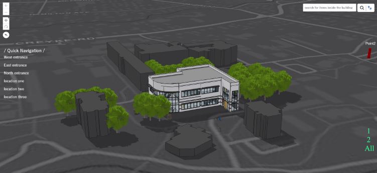
    Bingyu’s project entitled Fire rescue descision system using ArcGIS and BIM utiltised ArcGIS Pro, ArcGIS Enterprise, ArcGIS Online and the ArcGIS API for JavaScript and BIM in combination to simulate fire emergency evacuation routes and to enhance emergeny management. It enabled spatial query and escape route-planning in the 3D environment both internally and externally to a building. This resulted in simulation results that are more accurate, closer to reality and mre easily understood.

    A video of the web application that Bingyu created can be viewed at https://youtu.be/PrAJJG2hcFI

    The judges would like to also highly commend Callum Smith for his project entitled Automating Aspects of the BIM Visualisation Stages & Improving Stakeholder Engagement During Engineering Design for Accelerated Infrastructure Development.

    Thank you to all the other young scholars who applied for the NZ Esri Young Scholar Award in 2020. Your submissions were of the highest standard and made the judge’s job in choosing the best project very difficult.

  • NZ Esri Young Scholar 2019 announced!

    NZ Esri Young Scholar 2019 announced!

    The Esri Young Scholar Award is about recognising the very best GIS students around the globe. Every year, Esri’s global partners nominate 25 university students for excellence in relation to a GIS project. These projects include comprehensive research papers, software development, impactful maps, and apps that promote education, conservation, disaster response, and urban planning.

    NZ Esri Young Scholar Award 2019 – Winner

    It is with great pleasure that Eagle Technology announces Rose Mwipiko of Massey University as the Winner of the NZ Esri Young Scholar Award 2019.

    To recognise this achievement, Rose will be attending the Esri Education Summit and Esri User Conference in San Diego in July 2019. We look forward to hearing Rose’s reflections on the summit and conference on her return.

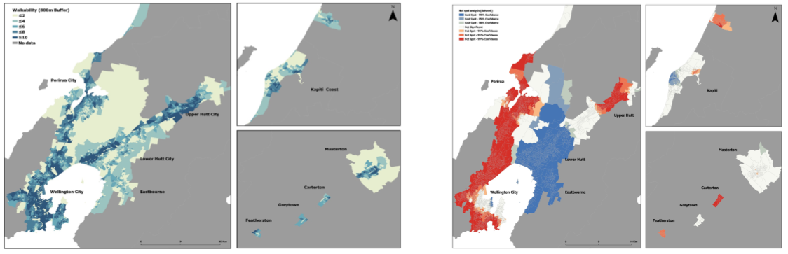
    Rose’s project entitled An exploration of the effects of the Built Environement on Depression in the Wellington Region focused on public health which is an area of geospatial that is slowly developing in New Zealand. Rose explored the relationship of walkability and mental health amongst adolescents in the Wellington Region. Rose’s study demonstrated an association between walkability and symptoms of depression in adolescents and demonstrated that a walkable neighbourhood may help to reduce depressive symptoms. Further research is required to test the walkability model with measures of depressive symptoms in rural and ethnically diverse locations. The findings presented in Rose’s research have implications for clinicians and policymakers. Rose suggests that future research should aim to determine if neighbourhood-level interventions based on characteristics of the built environment might improve health outcomes in adolescents. ArcGIS provided the platform for Rose to undertake her research into this innovative area of geospatial study.

    Thank you to all the other young scholars who applied for the NZ Esri Young Scholar Award in 2019. Your submissions were of the highest standard and made the judge’s job in choosing the best project very difficult.