Author: eagle_managewp

  • Trusted Geospatial Intelligence for Better AI-enabled Decisions

    Trusted Geospatial Intelligence for Better AI-enabled Decisions

    Artificial intelligence is moving rapidly from experimentation into enterprise strategy. Across sectors, organisations are under pressure to understand where AI can improve productivity, automate workflows, and support faster decision-making.

    But as AI adoption increases, many organisations are also facing a more difficult question, how do we make AI useful, trusted, and grounded in the real-world context our decisions depend on?

    For Eagle Technology, this is where trusted geospatial AI has a significant role to play.

    People, assets, services, risks, infrastructure, resources, and events all exist somewhere. That ‘where’ shapes decisions every day, from where services are needed, to where infrastructure is exposed, to where communities are affected, to where investment should be prioritised.

    Yet many enterprise AI systems are not inherently spatial. They are not designed to understand geography, spatial relationships, proximity, networks, boundaries, terrain, exposure, or the context that location provides.

    That creates a significant gap, AI may be able to process information quickly, but without trusted spatial context, it can miss where risk is concentrated, how assets and communities are connected, what is exposed, and where action will have the greatest impact.

    AI can generate answers, summarise information, and automate tasks. However, without trusted location intelligence, it can miss the spatial context behind real-world decisions.

    This is where Eagle has a clear role to play. Eagle enables organisations to bring trusted geospatial intelligence into AI-enabled workflows, so decisions are not only faster, but better informed, more contextual, and grounded in the realities of place, assets, risk, infrastructure, and communities.

    The market needs clarity, not more AI noise

    The AI market is moving rapidly. New tools, agents, assistants, models, and platforms are emerging at pace. For many organisations, this creates both opportunity and uncertainty.

    Eagle sees this every day through our work with customers across New Zealand. Organisations are not simply asking what AI is; they are asking what it can do for the problems they are trying to solve. They want to know how AI can reduce manual effort, make trusted data easier to access, support better operational decisions, and extend the value of the systems and platforms they already rely on.

    There is pressure to act, but also pressure to act responsibly. Customers need clarity on what AI can do today, what is still emerging, what is safe to pursue, and where investment will create measurable value. They also need a practical path for connecting AI to existing governance, data, security, and technology environments.

    This is particularly important in the geospatial space, where many organisations already hold significant value in ArcGIS environments, spatial datasets, imagery, LiDAR, asset information, field data, operational layers, and location-based workflows.

    The opportunity Eagle has identified is not simply for organisations to adopt new AI tools.

    It is to make trusted capability more accessible, more useful, and more connected to the wider enterprise AI strategies organisations are now developing.

    This is where Eagle’s experience matters. Through our work across ArcGIS, spatial data, enterprise systems, and customer delivery, we understand both the value locked inside environments and the practical challenges organisations face when trying to apply AI safely and effectively.

    The opportunity is to bring those worlds together, connecting trusted spatial data, workflows, and location intelligence into AI-enabled environments in a way that is practical, governed, secure, supportable, and focused on real customer outcomes.

    There are two connected but distinct paradigms when thinking about Geospatial AI.

    The first is AI in GIS: the development of AI tools, assistants, automation, analytics, and capability within ArcGIS to support GIS users and enhance existing workflows.

    The second is bringing GIS to AI. This is where Eagle recognises the opportunity to support customers in bringing trusted spatial data, ArcGIS services, workflows, and location intelligence into wider enterprise AI environments.

    Both stories matter, and they complement one another. Together, they show how AI can enhance the GIS environments organisations already rely on, while also enabling trusted spatial data, services, and workflows to support wider enterprise AI strategies.

    Esri is continuing to develop native AI capability within ArcGIS. Eagle builds on that platform direction by translating emerging capability into practical, customer-ready solutions for New Zealand organisations.

    At the same time, we enable customers to bring trusted GIS capability into wider AI workflows, agents, enterprise systems, and business processes, so spatial data and location intelligence are not left outside the enterprise AI conversation.

    This distinction matters because customers are moving beyond the question of what AI can do inside a GIS platform. They are asking how trusted spatial data, ArcGIS services, and workflows can connect into the systems, processes, and operational decisions that already shape their organisation.

    For Eagle, this is critical, bringing location intelligence into enterprise AI so spatial data is not treated as a separate technical layer, but as a key part of how organisations make better decisions.

    From AI potential to trusted geospatial value

    Eagle’s position is clear, AI-enabled capability should be practical, trusted, business-focused, and grounded in measurable value.

    It should not be treated as a chatbot, a demonstration, or a technology experiment in search of a use case.

    The value sits in the full solution, trusted spatial data, strong foundations, clear governance, secure integration, practical workflows, reliable architecture, and ongoing support.

    Graeme Henderson, CEO of Eagle Technology, says, “The real value of AI in the geospatial space is not in applying new technology without a clear purpose. It is in helping organisations make better use of the trusted spatial systems, data and workflows they already rely on. Eagle’s role is to help customers apply AI and ArcGIS safely and practically, so they can improve productivity, surface new insights, and make more confident decisions in the real world.”

    That is the practical opportunity.

    AI can reduce manual effort, help people access information faster, identify patterns, support scenario testing, and make specialist capability easier to use across the business. But those benefits only become meaningful when AI is connected to authoritative information, aligned to governance, and designed around real operational needs.

    Graeme Henderson says, “Enterprise AI will only become more valuable when it is grounded in the real-world context organisations operate in. Location is a critical part of that context. Most AI systems don’t automatically understand where something is happening, how assets, communities, networks, and risks relate to each other, or why location changes the decision. Eagle’s role is to bring trusted GIS capability into AI workflows, so customers can move beyond generic outputs and make decisions that are more relevant, more contextual, and more operationally useful.”

    Where AI value starts

    For many organisations, AI value does not begin with an agent, assistant, or automated workflow. It begins with readiness: trusted spatial data, clear metadata, appropriate permissions, strong governance, and the confidence that AI-enabled workflows are drawing from information that is accurate, authorised, and understood.

    This is why AI-ready spatial data is a critical foundation. It reduces the risk of inaccurate outputs, disconnected analysis, or AI systems drawing on information that is incomplete, duplicated, outdated, or poorly understood.

    With those foundations in place, AI-enabled workflows can create value in practical ways. They can make authoritative spatial information easier to access through natural-language interfaces, support faster analysis of imagery, LiDAR, drone, sensor, video, mobile, and field data, and enable predictive analysis by combining spatial, historical, environmental, operational, and business information.

    This can help organisations detect asset changes, assess damage, monitor remote environments, understand future risk, test planning options, prioritise investment, and communicate decisions more clearly.

    With the right foundations and governance in place, AI-enabled workflows can extend the value of GIS across the organisation, giving non-specialists guided access to trusted spatial insight while enabling GIS specialists to focus on higher-value analysis, advisory, and decision support.

    Building capability that lasts

    AI capability cannot be treated as ‘deploy and forget.’

    Platforms will evolve, business needs will change, security expectations will mature, and governance requirements will become more defined. For AI-enabled capability to deliver lasting value, it needs to be designed from the outset to adapt, scale, and remain supportable beyond the first prototype or implementation.

    That is why maintainability is central to Eagle’s approach. Customers need AI capability that can grow with their business, adapt as ArcGIS and AI capabilities advance, and avoid being locked into a single version, workflow, or short-term implementation approach.

    Eagle’s role extends across the full AI journey: strategy and advisory, enablement, delivery, and long-term scale, operation, and maintenance.

    We work with customers to identify where AI can create measurable value, build the internal confidence needed for adoption, deliver practical and governed implementations, and ensure capability remains secure, resilient, supportable, and aligned to evolving business and platform requirements.

    The organisations that gain the greatest value from AI will not be the ones chasing every new feature. They will be the ones building trusted foundations now, so they can move faster, more safely, and with confidence as capability matures.

    For Eagle, this is the opportunity to protect and extend the value of customers’ ArcGIS and spatial data investments, bring trusted location intelligence into enterprise AI, and support better real-world decisions through AI that is practical, secure, explainable, and commercially sound.

    The future value of AI will depend on how well organisations can connect intelligence to context, systems to workflows, and technology to the decisions that matter. That is where trusted geospatial expertise becomes essential.
  • Unlocking Artificial Intelligence for Geospatial Professionals

    Unlocking Artificial Intelligence for Geospatial Professionals

    [vc_row columns=”1″][vc_column][vc_column_text]By Nathan Heazlewood

    Introducing Eagle Technology’s New eBook

    Artificial Intelligence (AI) is rapidly reshaping industries across the globe, and the geospatial sector is no exception. Yet for many Geographic Information System (GIS) professionals, AI can feel complex, opaque, and difficult to engage with meaningfully. Recognising this challenge, Eagle Technology has developed a comprehensive eBook designed to bridge the gap between AI theory and practical geospatial application.

    Why AI Feels Complex

    AI is not a single technology but a multidisciplinary field that draws on computer science, mathematics, and involves elements of cognitive science and ethics. At its core, AI involves creating systems that can learn from data and make decisions or predictions. However, achieving this involves a broad range of techniques and concepts—each with its own language and underlying theory.

    For example, AI includes different advanced methods like:

    • Neural networks: computational systems inspired by the human brain that recognise patterns in data.
    • Deep learning: a subset of AI that uses multi-layered neural networks to process complex data such as images or time-series information.
    • Transformers and attention mechanisms: modern techniques that allow AI models to focus on the most relevant parts of data, improving performance in tasks like language processing and increasingly, spatial analysis.
    • Generative models: systems capable of creating new data, such as predicting future scenarios.

    Each of these components introduces its own terminology and workflows, making AI feel overwhelming—particularly for professionals whose expertise lies in spatial analysis rather than data science.

    The GIS-First Approach: Strengths and Limitations

    Many GIS professionals naturally approach AI by starting with familiar tools and workflows. This “GIS-first” approach often involves applying AI through software platforms such as ArcGIS to solve practical problems, including:

    • Automated feature extraction from aerial or satellite imagery
    • Land cover classification
    • Predictive modelling for environmental or urban planning scenarios
    • Image segmentation (dividing imagery into meaningful regions)
    • Spatiotemporal analysis (examining how geographic patterns change over time)

    This approach has clear advantages. It delivers immediate, tangible results and allows practitioners to enhance existing workflows without needing to fully understand the underlying AI mechanisms.

    However, it can also create a dependency on specific tools and limit deeper understanding. Without a solid grasp of the principles behind AI, it becomes difficult to:

    • Evaluate new tools and claims critically
    • Adapt to rapidly evolving AI technologies
    • Design tailored solutions for unique geospatial challenges

    A Concept-First Approach to AI Learning

    Eagle Technology’s eBook takes an alternative approach—starting not with tools, but with foundational AI concepts. This method is designed to build a strong conceptual framework that GIS professionals can apply across technologies and use cases.

    The eBook introduces key ideas such as:

    • What defines a neural network, and how it processes data
    • The distinction between machine learning and deep learning, and when each is appropriate
    • Attention mechanisms, which help models prioritise relevant information
    • Bias in AI, which can lead to unfair or inaccurate results if not managed
    • Explainability, the ability to understand and justify AI-driven decisions

    By clearly explaining these terms in accessible language and within a sequence of structured categories, the eBook removes much of the intimidation often associated with AI.

    Connecting AI Concepts to Geospatial Applications

    Once these fundamentals are established, the eBook bridges the gap to GIS by demonstrating how AI concepts directly apply to geospatial problems.

    For instance:

    • Convolutional Neural Networks (CNNs), a type of deep learning model, are particularly effective for analysing raster data such as satellite imagery because they can detect spatial patterns like edges, shapes, and textures.
    • Reinforcement learning can be applied to optimise transport networks, dynamically improving route selection based on changing conditions.
    • Predictive models can forecast environmental changes, urban growth, or infrastructure demands using historical spatial data.

    This dual perspective—concept first, application second—equips readers with both understanding and practical insight. It empowers GIS professionals not just to use AI tools, but to understand why they work and how to apply them effectively.

    A Resource for Professional Growth

    The eBook is designed as a self-development resource tailored to the needs of geospatial professionals. It supports:

    • Building confidence in AI terminology and concepts
    • Enhancing technical literacy across emerging technologies
    • Enabling more informed decision-making in projects and investments
    • Supporting innovation in geospatial solutions

    At the same time, it serves a secondary audience: AI practitioners who want to understand how their techniques can be applied in the geospatial domain. By providing context and examples grounded in GIS, the eBook fosters better collaboration between data scientists and spatial professionals.

    Enabling the Future of Geospatial Intelligence

    As AI continues to evolve, its integration with GIS will become increasingly central to solving complex spatial problems—from climate change modelling to smart city development. Understanding AI is no longer optional; it is a strategic capability.

    Eagle Technology’s eBook offers a practical and accessible pathway into this evolving field. By focusing on foundational concepts and connecting them to real-world geospatial applications, it provides the knowledge needed to move beyond tool-based usage and towards true AI-enabled innovation.

    For GIS professionals looking to stay relevant, competitive, and forward-thinking, this eBook is an essential step in that journey.

    View and download Eagle Technology’s eBook, Artificial Intelligence Glossary: AI Key Concepts, Terminology and Geospatial Considerations.[/vc_column_text][/vc_column][/vc_row]

  • How Auckland Council Uses Digital Twins for Infrastructure Planning

    How Auckland Council Uses Digital Twins for Infrastructure Planning

    Digital twin technology is transforming how New Zealand’s councils plan, manage, and maintain critical infrastructure. By creating real time 3D replicas of physical assets — from water networks to road surfaces — councils gain unprecedented visibility into the condition and performance of their infrastructure.

    The Challenge

    Auckland Council manages over $30 billion in infrastructure assets across the region. Traditional asset management relied on periodic inspections, spreadsheets, and disconnected systems — making it difficult to prioritise maintenance, forecast renewals, or respond quickly to failures.

    The Approach

    Working with Eagle Technology, the council implemented an ArcGIS-based digital twin that integrates IoT sensor data, LiDAR surveys, and existing asset registers into a unified 3D environment. The platform connects real-time data feeds with historical records, enabling predictive maintenance and scenario planning.

    “The digital twin gives us a single source of truth for infrastructure condition. We can now visualise, analyse, and plan in ways that were simply not possible before.”
    — David Thompson, Asset Manager, Auckland Council

    Key Outcomes

    Within the first year, the council reported a 30% reduction in unplanned maintenance events, 20% improvement in capital planning accuracy, and significantly faster response times to infrastructure failures. The platform also improved cross-departmental collaboration by providing a shared spatial view of all city assets.

    Looking Ahead

    The council is now exploring AI-powered anomaly detection and predictive analytics to further optimise infrastructure lifecycle management. Eagle Technology continues to support the programme with managed cloud services and ongoing GIS consulting.

  • NZ Esri RUCs

    NZ Esri RUCs

    RUCs 2026 – Coming to a centre near you

    This year’s 8-centre Regional User Conference series kicks off in Wellington on 23 March.

    Eagle Technology is once again collaborating with the NZ Esri Users Group to bring you the 2026 Regional User Conference roadshow.

    REGISTER NOW:

    Whangarei Distinction Hotel 21 April 2026
    Wellington National Library of New Zealand 23 April 2026
    Queenstown Queenstown Resort College (QRC) 29 April 2026
    Auckland The Grid 29 April 2026
    Tauranga Jordan Hall 30 April 2026
    Christchurch Black Box Theatre at Papa Hou 30 April 2026
    Blenheim Renwick Sports & Events Centre 5 May 2026
    Taranaki Novotel New Plymouth 5 May 2026

    Attendance is complimentary for NZEUG members, non-profits, students, and presenters.

    Attendance for non-members is $55. There are still a few complimentary tickets available for each venue. Be in quick to claim yours!

    Call for Abstracts

    We know our attendees love hearing GIS stories, whether big or small.

    Please submit your title and description through Submit Abstract.

    We hope you are as excited as we are to kick off the Regional User Conferences for another year – it is a great way to stay connected until the 2026 NZ Esri User Conference | 12 – 14 October at the New Zealand International Convention Centre.

  • GBS achieves Network Management Specialty

    GBS achieves Network Management Specialty

    Auckland, NZ (5 February 2026) —

    A logo of a company

AI-generated content may be incorrect.

    Eagle Technology’s long-term partner, Geographic Business Solutions (GBS), has been awarded the Esri Network Management Specialty in recognition of their expertise in ArcGIS for network management across water, electricity, and gas utilities.

    The certification is not just a badge but an acknowledgement that GBS customers can have confidence to engage with experts who can guide and assist with complex features and advanced technologies, driving innovation to improve ROI.

    As an Esri Gold Partner, this endorsement strengthens its partnership with Eagle Technology. Working together, Eagle and GBS deliver the ArcGIS Utility Network Programme which tailors expertise for the New Zealand utilities market. Both are now uniquely placed as world-class, certified experts in Network Management in New Zealand and the South Pacific.

    Esri’s selection to achieve Specialty status is rigorous, and GBS acknowledges the work and confidence of Brett Dixon, Infrastructure Group Lead, Esri APAC, and Eagle Technology in progressing this certification.

    Established in 2002, GBS has a long history working with Esri and ArcGIS.

    More about GBS here

  • Enabling Rapid ArcGIS User Onboarding

    Enabling Rapid ArcGIS User Onboarding

    Onboarding new ArcGIS users can be a time-consuming process. Between account setup, permissions, and group assignments, the process often requires input from an administrator, which can cause delays. For times where agility matters—infrastructure projects, emergency response—these delays can be critical. 
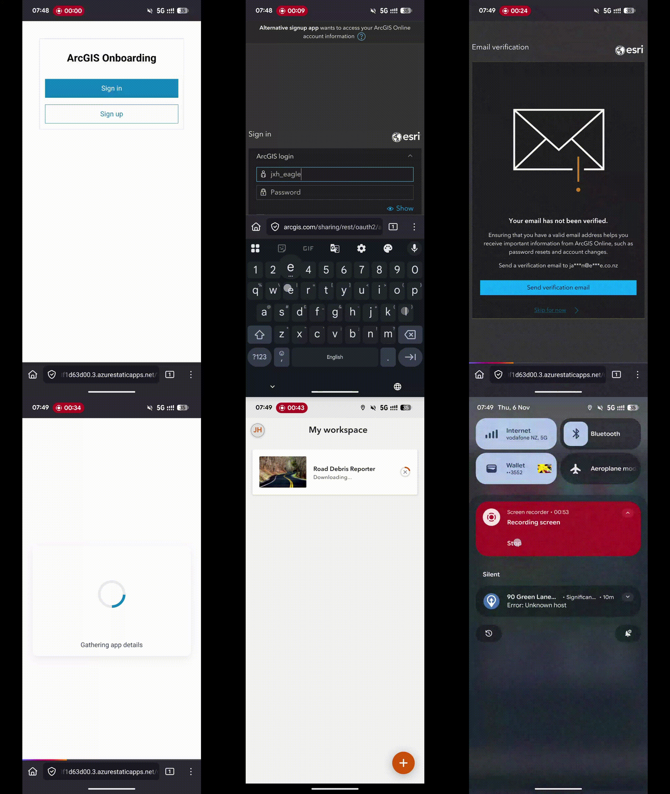
    The ArcGIS Self-Service Onboarding GitHub repository outlines how to deploy a lightweight onboarding site—typically in Azure, though it can be adapted for other platforms. This site allows you to generate a URL (or QR code) that users can visit to onboard themselves into pre-defined groups in your ArcGIS Enterprise or ArcGIS Online organisation. 

    After scanning the QR code, users sign in with their existing ArcGIS account or (if enabled) create a new one. The site then automatically adds them to the correct ArcGIS Online or ArcGIS Enterprise group and redirects them to a pre-defined URL, which could be an ArcGIS Experience, QuickCapture project, or something else!

    How It Could Be Used 

    • Emergency Response Teams
      During flood or cyclone events, agencies need to onboard additional field staff rapidly. A self-service system means responders can access critical mapping tools immediately, supporting faster decision-making and coordination. 
    • Infrastructure Projects with Multiple Contractors
      Large projects—think roading or water infrastructure—often involve external consultants who need access to shared maps and dashboards. Self-service onboarding ensures these users can join the right collaboration groups quickly, without exposing sensitive data or requiring lengthy email chains. 
    • Regional Council Onboarding Seasonal Staff
      Councils often hire temporary staff for environmental monitoring during summer. Instead of IT manually creating accounts for each contractor, the onboarding portal allows them to self-register, automatically assigning them to the correct ArcGIS Online groups for data collection apps like ArcGIS Survey123. 
  • Haukapuanui Vercoe – 2025 New Zealand Esri Young Scholar

    Haukapuanui Vercoe – 2025 New Zealand Esri Young Scholar

    I am incredibly honoured to have received the 2025 New Zealand Esri Young Scholar Award and to represent Aotearoa at the Esri User Conference in San Diego. I would like to extend my sincerest thanks to Eagle Technology and Esri for this prestigious recognition and the ongoing support of emerging researchers who are using GIS to address critical, real-world challenges.

    My project—Adaptations of Marae for Natural Hazards Resilience—sits at the confluence of civil engineering, geospatial science and Indigenous knowledge.

    By Haukapuanui Vercoe, Engineering PhD researcher

    I am incredibly honoured to have received the 2025 New Zealand Esri Young Scholar Award and to represent Aotearoa at the Esri User Conference in San Diego. I would like to extend my sincerest thanks to Eagle Technology and Esri for this prestigious recognition and the ongoing support of emerging researchers who are using GIS to address critical, real-world challenges.

    My project—Adaptations of Marae for Natural Hazards Resilience—sits at the confluence of civil engineering, geospatial science and Indigenous knowledge. Recent natural hazard events have recurrently seen marae play a key role in civil defence response, recovery and relief efforts, providing support and shelter for the community. As vital forms of sociocultural infrastructure, it is critical to better understand their exposure to natural hazards such as flooding, earthquakes or tsunami. Through spatial analysis alongside kaupapa Māori research methods, this work aims to enhance the climate, natural hazard and infrastructure resilience of marae. This award is particularly meaningful because it reflects academic achievement, but importantly the value of culturally grounded, community-focused research. I feel privileged to be working in a space where my whakapapa (genealogy), engineering background, and commitment to supporting marae-led adaptation efforts converge through tools like GIS.

    Showcasing this work at the Map Gallery in San Diego, alongside Young Scholars from around the world, was an unforgettable highlight. The conference provided unparalleled opportunities to learn from global leaders in spatial science, connect with professionals across diverse sectors and gain new insights into how GIS is supporting communities worldwide.

    One of the most meaningful aspects of the Esri User Conference was learning from the experiences of Indigenous communities across the United States. Hearing how they are harnessing the power of GIS to serve their people—whether through environmental stewardship, cultural preservation, or infrastructure planning—was inspiring and offered ideas I am eager to bring home.

    A group of people posing for a photo

AI-generated content may be incorrect.

    I was equally excited by the possibilities emerging from the integration of artificial intelligence with GIS. The ability to make processes faster, more accurate, and more connected—perfectly aligning with the conference theme, GIS: Integrating Everything Everywhere. Seeing these capabilities in action has sparked new ideas for how I might weave AI into my own current and future research.

    Attending the Esri User Conference was a truly transformative experience and I am deeply grateful to Eagle Technology for this opportunity. The manaakitanga (hospitality) shown by the Eagle Technology team, who made me feel so welcome and supported throughout the week, was second to none. I have returned home inspired by the scale and diversity of GIS innovation and more motivated than ever to continue supporting marae, whānau, hapū and iwi through applied spatial research

  • ArcGIS CityEngine Street Designer

    ArcGIS CityEngine Street Designer

    For years, urban designers and procedural modelers have faced challenges with the ArcGIS CityEngine Complete Streets rule—its complexity required meticulous parameter tuning, slowing down workflows. CityEngine 2025.0 Beta introduces Street Designer, a modular lane-based system that simplifies street creation, improves customisation, and enhances export flexibility for visualisation in game engines and 3D visualisation software.

    Background

    The design process for streets in CityEngine got a boost in 2015 with the publication of the Complete Streets rule. Developed by David Wasserman during his internship at Esri, this rule allows creation of complex street designs with the option for adding details like vehicles, pedestrians, streetlights and other street furniture, reporting options including painting, braking sight, object counts and more. While the Complete Streets rule offered extensive customisation, its sheer number of interdependent parameters made design workflows increasingly complex—requiring significant adjustments to achieve desired results. David wrote the unofficial user guide for this rule spanning 46 pages.

    After departing Esri, David continued updating his version of the rule on the Esri Community site until 2020. Esri’s official version of the Complete Streets rule is included in CityEngine example ‘Example Complete Streets’ and it is continually developed and maintained.

    Present Day

    A decade later, Esri revisited the design and shifted towards a simpler approach. The result is Street Designer. The Street Designer is a modular approach for simpler street design. In Street Designer a street is configured as a roadbed (centreline) and a number of lanes – road lane, bus lane, pedestrian lane, trees, lamps, furniture lane. For each lane, the user can apply individual rule and therefore the design is simplified. Instead of one large rule there is a number of smaller ones, easier to understand and modify.

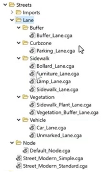
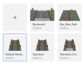
    As part of the transition to Street Designer ESRI.lib has new rules for different types of lanes as shown in the screenshot below.

    Street Designer implements a lane-based modular system. This structured approach enables transport planners to refine lane assignments and individual rules improving procedural modelling flexibility without relying on a single monolithic rule system.

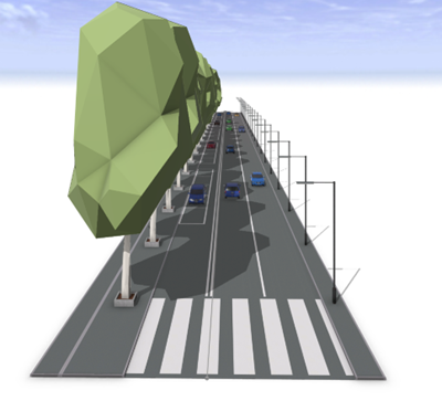
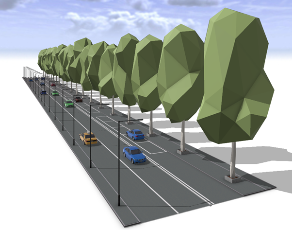
    Here is an example of the street designed in Street Designer.

    How to create a street using Street Designer?

    The design process consists of four steps:

    • Create a street using the Street Creation Tool
    • Add or remove lanes from Edit Lanes window
    • Assign rules individually, selecting rules from ESRI.lib for each lane enabling precise customisations
    • Modify attributes for lanes based on design needs

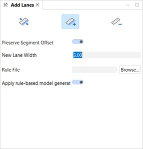
    The starting point is to use the standard Street Creation Tool and draw a street. Once the street is created, add lanes with the new Street Designer tool. This tool is easy to use, with visual cues where lane can be added. For finer control use the Edit Lanes window shown in the screenshot below.

    The next step is rule assignment. The new rules created for Street Designer are included in the ESRI.lib folder in current workspace. You need to apply rules to each lane individually.

    The final step is modifying the attributes for each lane. Each rule has different attributes providing fine grain design details.

    If you are working on a large area with many streets there is a lot of manual work and detailing with attributes. However, Street Designer has a feature called the Street Configuration that allows for the creation of a library of standardised street designs. These standardised street deigns can be applied to any street layout across multiple projects via the Street Configuration Manager providing visual feedback when necessary.

    Exporting

    With Street Designer, each lane can be exported as a separate set of objects. This modular approach simplifies asset replacement workflows, enabling users to substitute default objects with meshes optimised for game engines.

    Using Complete Streets rules meant you didn’t have access to street furniture, for example, as separate objects once street models are exported from CityEngine. This meant that users would need to create all details including benches, parking metres and streetlights or create placeholders and then replace them in the game engine with blueprints or higher quality assets.

    With Street Designer it is now possible to handle every lane separately and when exported they are exported as separate objects. This means that it is now a simple task to modify separate objects in applications such as in Unreal Engine with a blueprint that includes high quality mesh and light source with optional use of IES profiles. If you like the assets from CityEngine you can even use static meshes in your own blueprints for simpler workflow.

    This workflow improvement reduces time working in Unreal Engine significantly. Below is a street created with Street Designer, exported as a Datasmith file and then imported into Unreal Engine where the original streetlights objects were replaced with a simple blueprint containing a light source.

    Street Design in ArcGIS CityEngine

    Street Rendering in Unreal Engine

    For visualisation of larger areas or subdivision with numbers of streets and visualisation at night I would use Unreal Engine’s Megalights but that is a subject for another blog post.

    With modular street configurations, urban designers, city planners and game developers can refine workflows for maximum efficiency.

    How will you apply Street Designer in your next project?

  • Deprecation of the Classic New Zealand Basemap Server – Effective 5 May 2025

    Deprecation of the Classic New Zealand Basemap Server – Effective 5 May 2025

    As part of Eagle Technology’s ongoing work to provide up-to-date, high-performance basemaps compatible with current ArcGIS technology, we want to inform you about an important update to our basemap services. Please review the details below to ensure a smooth transition and optimal use of these basemaps in your work.

    – Boudewijn Boogaard

    Key Points

    • Deprecation notice: Starting 5 May 2025 Eagle Technology will deprecate our “Classic Basemap Server”.
    • Redirection: URLs referencing the “Classic Basemap Server” will be automatically redirected to the “Current Basemap Server” which hosts all of the same basemaps but with a different tiling scheme.
    • Users should Identify if applications are making use of the “Classic New Zealand Basemap server”: The attributes at the bottom of the page will show “Classic Basemap Server” if this is the case.
    • Migration Advice: If you identify that you are currently using the “Classic Basemap Server” then, based upon which specific basemap you are using, consider the following:
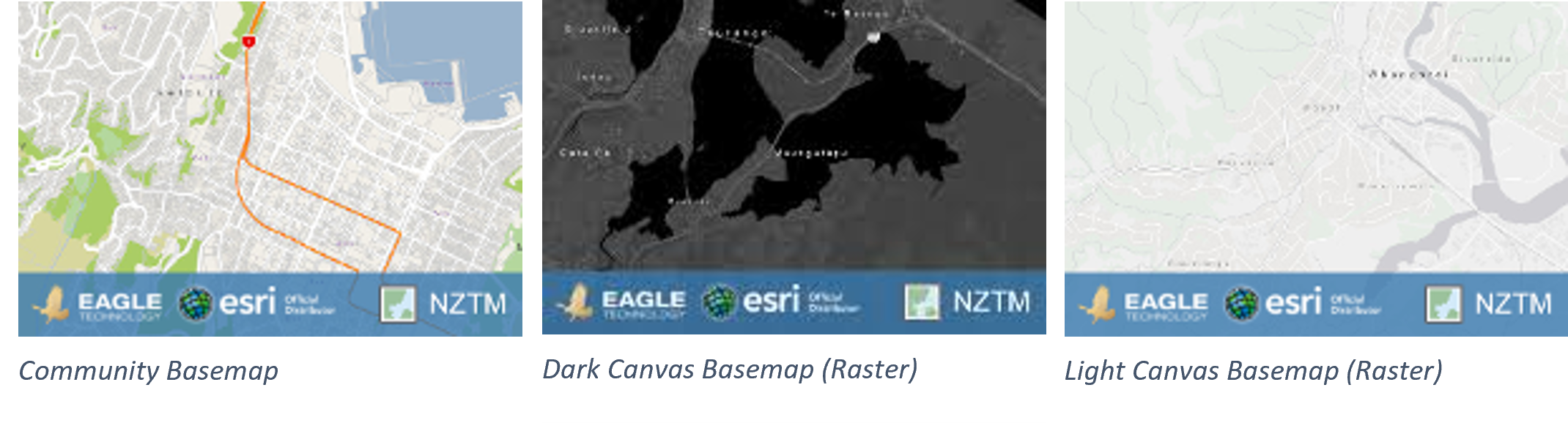
      • For users of the Community Basemap or the Dark Canvas Basemap (Raster), and the Light Canvas Basemap (Raster), see images below, these services have been in mature support since December 2022 on both the classic and current basemap server and no longer receive updates. We therefore strongly recommend transitioning to Vector Basemaps.
      • Manually migrating to the Current Basemap server or Vector Basemaps will allow proper testing and avoid potential disruptions.

    Background

    For over a decade, Eagle Technology has provided authoritative New Zealand basemaps in the NZTM projection to ArcGIS users. Over this time, significant advancements have been made, including:

    1. Introduction of Vector Basemaps; In December 2019 we introduced NZ Vector Basemaps, offering improved performance and functionality.
    2. Introduction of a New Basemap Server with a consistent tiling scheme; In early 2020 we deployed a new basemap server hosting the same basemaps, but with a consistent tiling scheme across all basemaps on that server for improved compatibility. The updated scheme includes:
      • 5 Additional small-scale zoom levels.
      • Larger scale zoom levels, enabling zooming to at least 1:70.
    3. Transition of Raster Basemaps to Mature Support in December 2022, as equivalent Vector Basemaps became available. This included both the Community Basemap and the Light and Dark Canvas Maps. See this blog for the announcement.

    What’s Changing?

    There are two basemap servers that host the same basemaps. The Classic Basemap Server hosts the basemap with different tiling schemes across the basemaps, the basemaps on the Current Basemap Server all have a consistent tiling scheme.

    We will redirect the URLs that currently go to the Classic Basemap Server to the Current Basemap Server.

    The basemaps on the Classic basemap server haven’t received any data updates since December 2022. The basemaps on the Current basemap server hosts basemaps that are in mature support, so they are also not receiving any updates, but the NZ Imagery and the LINZ Topographic basemaps are still being actively maintained.

    When you are using a basemap that is in mature support, we recommend migrating to one of the Vector Basemaps. Please read the blog with more information on this here.

    Scenarios That May Require Action

    While many users will experience a seamless transition, there are scenarios where adjustments may be required:

    1. Tiling Scheme Incompatibilities: Custom tiled layers aligned to the Classic Basemap tiling scheme may no longer overlay correctly. This mainly happens in 3D applications like Scene Viewer. The custom tiled layers must be re-cached using the new tiling scheme.
    2. Zoom Level Changes: Apps or URLs using specific zoom level IDs will require updates. For example, a zoom level ID of 14 on the Classic Basemap corresponds to ID 19 on the Current Basemap server.
    3. Cache and Map Updates:
      • In ArcMap: Clear the Display Cache.
      • In ArcGIS Pro: Reopen the map or project.

    Please note: These scenarios are not exhaustive, other issues may arise depending on your specific workflows or applications. We recommend thorough testing to identify and address any additional challenges.

    URLs Impacted

    The URLs that are currently directed to Classic Basemap Server and will be redirected to the Current Basemap Server are:

    • https://server.arcgisonline.co.nz/arcgis/rest/services
    • https://services.arcgisonline.co.nz/arcgis/rest/services
    • https://basemaps.cloud.eaglegis.co.nz/arcgis/rest/services

    Identify if a basemap from the Classic Basemap server is used.

    There are a few ways to identify if you are using a basemap from the Classic basemap server. You know it is coming from the Classic Basemap Server if:

    • the attributes, usually on the bottom of the map, says “Classic Basemap Server”.
    • the title of basemap layer item or the WebMap item has “Classic” in the name
    • the URL to the basemap is one of the impacted URLs

    These URLs will remain active but will be directed to the Current Basemap server.

    When migrating manually to the new server before the update, please use the services from this URL: https://services1.arcgisonline.co.nz/arcgis/rest/services

    Advised actions

    We strongly encourage users to:

    1. Identify all maps, layers, and apps that use basemaps that use the Classic Basemap server.
    2. Test and or migrate the layers to the Current Basemap server or a Vector Basemap.
    3. Update any hardcoded URLs or zoom-level parameters as needed.

    There are many ways to update the URLs depending on the situation.

    • Update the basemap in the WebMap by opening the webmap and selecting a current basemap as the new basemap for the map.
    • Update the group that holds the basemaps for the organisation’s basemap gallery. Remove the classic basemap webmaps and add webmaps with the current basemaps.

    A tool that can be helpful with updating maps and apps is the ArcGIS Assistant on https://assistant.esri-ps.com/. This tool allows you to update URLs in layers, maps and apps. Be sure to read the user guide to familiarise yourself with its capabilities.

    Basemaps in Mature support

    For users of CommunityDark Canvas or Light Canvas raster basemaps from either the Classic or the Current Basemap Server, we highly recommend transitioning to Vector Basemaps to benefit from the latest updates and support. These basemaps have been in Mature support since December 2022 which means that they have not received any data updates since then.

    HTTPS to be enforced for Eagle Basemaps

    For reasons of backwards compatibility, Eagle has allowed access to our raster basemaps using both HTTP and HTTPS. To stay in line with industry guidelines we will be enforcing HTTPS access only to our Eagle basemaps from July 2025. Any requests in HTTP will be redirected to HTTPS. In many cases the redirect will work, however there may be some specific cases where the redirect does not work, including some circumstances within custom developer applications. In these cases, the developers will need to update their applications and tools to accommodate HTTPS.


    Resources

  • ArcGIS and Power BI

    ArcGIS and Power BI

    By Jake Hanson – GIS Advisor

    Accessing ArcGIS feature layer attribute data in Power BI using a Custom Data Connector

    Many organisations use ArcGIS for geospatial analytics, visualisation, and data capture, alongside Power BI Desktop, which creates interactive reports and dashboards from a variety of data sources. However, ensuring that users across both platforms work with consistent data and provide uniform reporting to stakeholders can be a significant challenge.

    This post describes how you can compile and configure a Power BI Custom Data Connector to simplify the process of using up-to-date ArcGIS data in your Power BI reports.

    What is a Custom Data Connector?

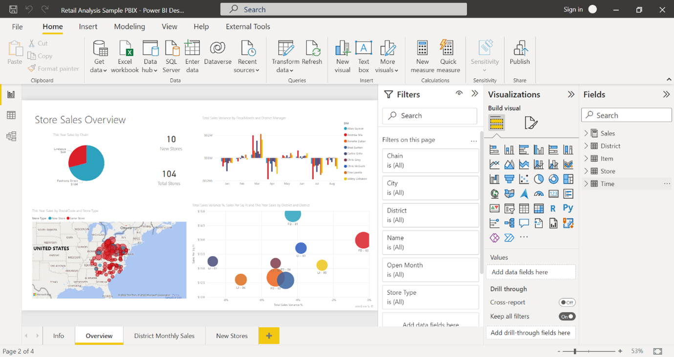
    Power BI comes with many data connectors out-of-the-box, for example, allowing you to connect to an Excel Spreadsheet, Parquet, or a SQL Server table. 

    However, Microsoft also allows you to build your own data connector if your data is in a format that is not natively supported. As there is no native connector for ArcGIS, this post will show you how you can build your own that handles authenticating with ArcGIS, querying a feature layer, paging through the results and loading them into a report.

    When should I use the custom data connector rather than other workflows?

    There are several other documented workflows for bringing your ArcGIS data into Power BI, and each has its own advantages and disadvantages, briefly outlined in the table below:

    Workflow

    Great for

    Limitations

    Using ArcGIS Maps for Power BI to visualise your ArcGIS data within Power BI Desktop

    • Quickly bringing in an ArcGIS map into your Power BI report
    • Doesn’t support analysis of attribute data in Power BI.

    Automating data export to CSV using Power Automate or in bulk with FME or Python

    • Larger ArcGIS datasets
    • Scheduling exports out-of-hours
    • Sharing data with non-ArcGIS users
    • Requires data to be downloaded to a staging area for use

    Directly querying a feature layer using a Web Connection within Power BI Desktop

    • Quickly loading in a small amount of data into Power BI.
    • Only supports small datasets (usually <2000 features).
    • Difficult to refresh the data to get the latest updates

    Using a Power BI Custom Data Connector

    • Seamless – handles authentication, data wrangling for you
    • Refresh data at the click of a button
    • Great for development and testing
    • Users needing to refresh or add new data will need access to ArcGIS accounts
    • Regular requests for tens of thousands of features will have a performance impact on the server.
    • You need to allow non-certified connectors in Power BI Desktop to use custom connectors.

    How would I build a custom data connector?

    Fortunately, most of the work has already been done for you. This GitHub repository contains the basic code for the connector. There’s a little bit of work needed to configure and compile the connector for the ArcGIS Online organisation or ArcGIS Enterprise instance which contains the feature layer(s) you want to access. The steps for this are outlined below.

    How do I configure and compile the connector?

    1. The first step is to install Visual Studio Code, a free text editor and Integrated Development Environment (IDE) with powerful built-in tools, including tools to compile Power BI Data Connectors.

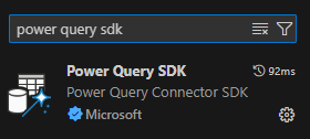
    2. Follow this guide to install the Power Query SDK Extension for Visual Studio Code.

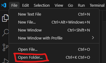
    3. Download this GitHub repository by clicking on the green “Code” button and “Download as zip”. Unzip the compressed folder, then open the folder in Visual Studio Code.

    4. The next step is to register an App in ArcGIS Online or Portal (wherever the data is that you want to access). This will create a Client ID and Secret that will be used to allow the Data Connector to authenticate with ArcGIS. 

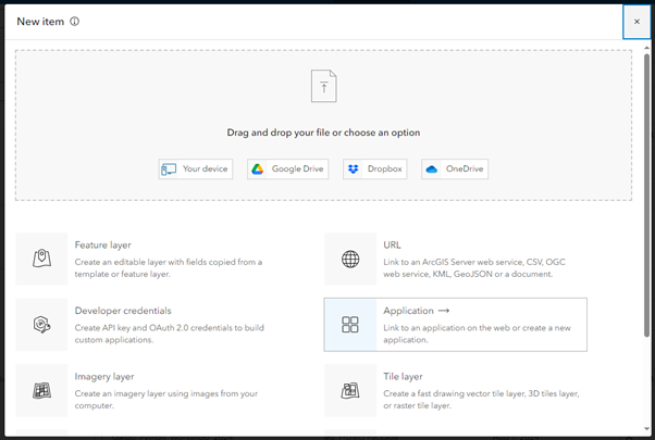
    a. Go to My Content > New Item > Application 

    b. Create an application of type “Other application” 

    c. Name it Power BI Desktop.

    5. In the page that opens, click Settings

    6. In the URL box add https://localhost.local

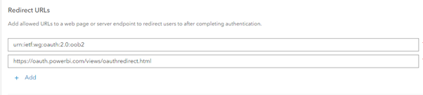
    7. Scroll down and add https://oauth.powerbi.com/views/oauthredirect.html to the Redirect URI box. 

    Click Add, then Save to complete the app registration process.

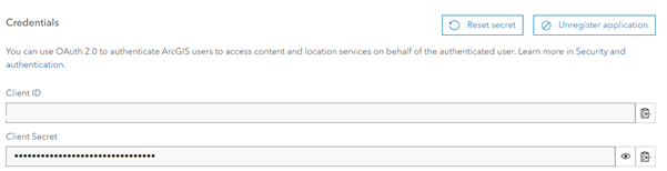
    8. Scroll to the Credentials section and copy the Client ID. In Visual Studio Code, paste it (overwriting the existing text) into the client_id.config file.

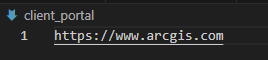
    9. Update the client_portal.config file in the cloned repository to your ArcGIS Online or Portal URL.

    10. In the connector_name.config file, update the file to reflect the name of the environment (e.g. ArcGIS Online Feature Layer or Eagle Enterprise PROD Feature Layer) so that users know which Portal’s feature layers they can connect to using this connector.

    11. Now we have finished configuring the connector, we can compile it into a Power BI Connector. Press F1 and type “Build Task”. Select the Tasks: Run Build Task option.

    12. Select “Build project using MakePQX”. This will build the Connector and store it as a .mez file in the unzipped folder’s ‘…/bin/AnyCPU/Debug’ folder.

    I’ve compiled the connector, how do I install it?

    1. Create the folder C:\Users\<user>\Documents\Power BI Desktop\Custom Connectors if it doesn’t already exist.

    2. Copy the .mez file from <unzipped folder>/bin/AnyCPU/Debug into the new ‘Custom Connectors’ folder.

    NOTE: While it is possible for multiple users to use the same .mez file (i.e. an administrator could create and share a .mez file and associated Portal item with all organisation members), the client ID and secret are easily accessible in plain text in the .mez file, meaning there is a possible risk that a knowledgeable user could re-use these credentials to impersonate your application.

    How do I use the connector once it is installed?

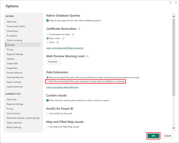
    1. In Power BI, under Options and Settings > Options > Security, enable non-certified connectors. Microsoft certifies a limited subset of custom connectors, but as we are building this one on-the-fly, the connector you create will not be certified. 

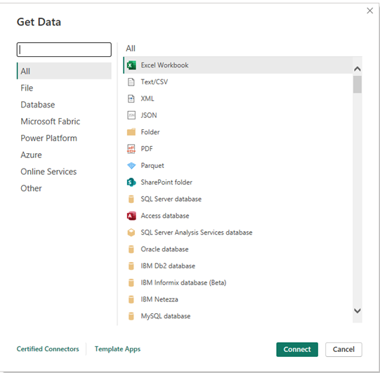
    2.  Now you’re ready to use the connector to add ArcGIS data into Power BI. Under the Home tab in your report, click Get data, click ‘More…’ at the bottom of the menu, and Search for “ArcGIS”. Your connector should appear in the list. Click it then click “Connect”

    NOTE: If you don’t see the Custom Connector in the list, it may be because the version of Power BI being used has been downloaded from the Microsoft Store. It is recommended that Power BI be downloaded directly from the official Power BI Website: https://www.microsoft.com/en-nz/power-platform/products/power-bi/desktop

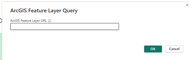
    3.  Enter the URL for the Feature Layer you want to add to your Power BI model, ideally suffixed with a compliant query (filter) as described in the Query documentation.


    NOTE: It is highly recommended to use a query to remove any records you don’t need to use in your report to reduce the load on the ArcGIS server. Example: Only the features with an OBJECTID less than 1000 will be returned. https://services.arcgis.com/hMYNkrKaydBeWRXE/ArcGIS/rest/services/Addresses_geocoded/FeatureServer/0/query?f=json&outFields=”*”&where=OBJECTID<1000&returnGeometry=false

    NOTE: If you provide a feature layer URL without a query, which will look like this: https://services.arcgis.com/hMYNkrKaydBeWRXE/ArcGIS/rest/services/Addresses_geocoded/FeatureServer/0/query?f=json&outFields=””*””&where=1=1&returnGeometry=false
     
    NOTE: If you provide a feature layer URL without a query, which will look like this:
    https://services.arcgis.com/hMYNkrKaydBeWRXE/ArcGIS/rest/services/Addresses_geocoded/FeatureServer/0
    The default query below will be used, to request all the features: query ?f=json&outFields=””*””&where=1=1&returnGeometry=false 

    NOTE: The geometry is never returned by the connector.

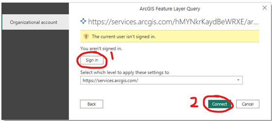
    4.  Click OK, then click Sign in. This will prompt you to sign in with your ArcGIS credentials. Once signed in, click Connect to load your data into your Power BI report.

    Now you should see your ArcGIS data in Power BI!

    When you hit the Refresh Data button, the connector should handle the authentication and pull in the latest data from ArcGIS! If you are signed out, the dialog above will display. Simply click “Sign in” again to reconnect to ArcGIS.