Author: eagle_managewp

  • Esri User Conference Experience 2023

    Esri User Conference Experience 2023

    Rachel Lawson – University of Auckland and NZ Esri Young Scholar Award Winner 2023

    I was fortunate enough to win this year’s New Zealand Esri Young Scholar Award for my work title “What were the impacts on human mobility during the New Zealand International Convention Centre Fire?”” completed during the Bachelor of Science Honours in Geography postgraduate studies at the University of Auckland. I set out to identify disruptions to movement corridors, exposure to smoke/air pollution, and emergency and citizen response in Auckland, New Zealand using GIS datasets and social media images. I heard about the award through my master’s supervisors, Dr Katarzyna Sila-Nowicka (Sila) and Associate Professor Daniel Exeter who recommended I put my work forward. I’d heard how amazing the conference was from previous winners and was surprised to win. I had not travelled long haul before and all my scheduled travel during my Masters and BSc(Hons) postgraduates degrees was cancelled or converted to virtual due to the pandemic, so the award and trip was especially exciting for my professional and personal development.

    During the conference I meet with other young scholars from around the world including Spain, India, Colombia, France, Sweden, and other European countries. We explored not only the user conference but also attended the education summit for two days prior to the UC, which included hands-on learning labs and workshops, presentations, and networking. As a group we also travelled to Coronado Island and other tourists’ attractions during the shorts breaks between events.

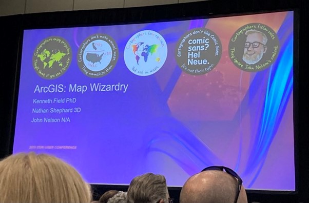
    My favourite presentation during the conference was a panel session by John Nelson, Ken Field, and Nathan Shepard titled Map Wizardry. During the presentation raw datasets were converted in exciting and visually appealing cartographic designs using basic tools in ArcGIS. It has inspired me to add more design flare to my outputs, without needing to spend too much additional time in the process. I also enjoyed the expo, and meeting/complaining to product designers, hopefully some of my suggestions influence upcoming modifications. And I’m particularly excited by upcoming changes to ArcGIS for Microsoft 365, which should increase my day-to-day productivity and enable teammates to collaborative view our projects on teams.
    During the conference I was able to attend many social events including Kiwi Night, Young Professionals Pool Party, a Baseball Game with Eagle Staff and more. In each event I was able to build new connections internationally and within New Zealand which will continue to help my work in science research now at GNS, a crown research institute.  I also enjoyed weekend break after the conference exploring the sunny San Diego Coast including a trip to the USS Midway Museum, SeaWorld theme park, San Diego Zoo, outlet shopping at the Tijuana border and a sailboat trip before returning to New Zealand winter and work.

    I owe a massive thank you to Esri, and Eagle Technology for funding my travel and award, along with the support during the travel. I thoroughly recommend any students or recent graduates take the time to share their work and apply for this award in the future.


  • Creating an Esri Academy Learning Plan

    Creating an Esri Academy Learning Plan

    Learn how to create a Learning Plan of eLearning resources within the Esri Academy site. 

    Creating a custom Learning Plan in Esri Academy can help you or your colleagues focus their learning on a particular ArcGIS topic or product.

    The process for creating a custom Learning Plan is as follows:

    1. Open the Esri Academy
    2. Sign in
    3. Once you have successfully signed in, click My Academy > My Learning Plans
    4. On the My Learning Plans page click the Create a Learning Plan button on the top right of the page
    5. Give your Plan a Title and a Description
    6. Click Create New Plan
    7. If you know the titles of the eLearning resources, you would like to add to your plan you can start typing them in the add courses text box e.g. GIS for Climate Action.
    8. Alternatively, you can add eLearning directly from the Esri catalog
      • Search for a course e.g. ArcGIS Pro Basics
      • Locate the circle with the plus button within it on the course banner heading and click
      • Select a Plan to add the course to – this should be the plan you created earlier in this process.
      • Click Add to Plan
      • Click Close
    9. Once you have added all the courses you want to, to the learning plan you can return to the My Learning Plans page to view your Learning Plan
    10. To change the order of the courses in the plan:
      • click the edit plan button under the Learning Plan name
      • hover your cursor over the four headed arrow icon in the vertical colour strip on the left of the course card
      • Click, hold and drag the course card to the correct position in the Learning Plan.
      • Release your cursor
    11. Save the plan once you have made all the reordering of courses
    12. If the learning plan is to be used by multiple people in your organisation you can assign the plan to these people.
    13. To assign the plan
      • Locate and click the Assign Plan link just under the Learning Plan title
      • Enter the email addresses of the people you would like to assign the learning plan to (separate multiple email address with a comma or a space)
      • Add a message to the person who will be receiving the assignment of the Learning Plan
      • If required, add a date of when the Learning Plan needs to be completed by
      • If necessary, preview the email and make the desired changes in your personal message.
      • Once you are happy with the content of the email click the Send Invite button.
      • A view assignments button will appear beside the Edit plan button on the learning plan once the invite has been sent.
      • The person or people you have assigned the plan too will receive an email to enrol in the plan. Until they have enrolled in the plan their status under the view assignments button will be set to Not Accepted. You can resend the invite to enrol in the Learning Plan. Once a person has enrolled in a Learning Plan their status will be set to Enrolled. As the owner of a Learning Plan you can track peoples progress in completing the Learning Plan.

    Requirements

    To be able to create a learning plan on the Esri Academy site you need to be signed in to https://www.esri.com/training/ with either a My Esri username and password or an ArcGIS Online username and password with Esri access enabled. Refer to the Accessing Esri Academy eLearning resources blog for more details.

    Exceptions

    Eagle Technology Instructor-Led courses from our course catalogue cannot currently be added to Esri Academy Learning Plans. If you have access to a private catalogue within Esri Academy eLearning resources from this catalogue are also not available to be added to an Esri Academy Learning Plan.

    Final note

    There are Esri created Learning Plans available for you to enrol in. For a list of Esri created Learning Plans visit https://www.esri.com/training/learning-plans/ and change the Plan Created by Filter to Esri Plans. Some of the Esri created Learning Plans contain links to Esri run Instructor-Led courses. If you would like to attend the equivalent Instructor Led course in New Zealand time and pay for the course in NZ dollars please visit https://www.eagle.co.nz/learn/course-catalogue to find out when the Instructor Led course is next running via Eagle Technology. If you can’t find the Instructor Led course on the Eagle schedule please contact gistraining@eagle.co.nz.

    If you would like some assistance with setting up an Esri Academy eLearning Learning Plan, please contact gistraining@eagle.co.nz.

  • How do I estimate ArcGIS Online credit usage?

    How do I estimate ArcGIS Online credit usage?

    Learn some tips and tricks about how you can monitor credit usage for different activities across your ArcGIS Online organisation including individual member usage.

    Purpose of ArcGIS Online Credits

    ArcGIS Online credits are a form of currency used across the different ArcGIS products. These are consumed on specific transactions (e.g., Analysis Tools) and storing specific features. However, most activities in ArcGIS Online do not use credits (e.g., adding layers from the Living Atlas into a web map).

    Usage of Credits

    Credits in ArcGIS Online are consumed when there is a transaction-based tool being used. These include:

    • Performing Spatial Analysis Tools
    • Performing Imagery Analysis
    • Geocoding Points

    Furthermore, credits are used for storage. There are three types of storage that consume credits:

    • Feature Storage (such as feature layers hosted in ArcGIS Online)
    • Imagery Storage
    • File Storage (such as attachments in the hosted feature layer, files, and other layers)

    As an Administrator of an ArcGIS Online subscription, you want to keep track of the use of credits within your organisation. By monitoring credit usage, you can determine if it is necessary to:

    • reduce data storage,
    • reduce credit consumption,
    • plan for purchasing credits if required. 

    As an ArcGIS Online user, you can estimate the ArcGIS Online credits it would take to perform a transaction-based activity or to store specific data. This would benefit your organisation by ensuring credits are utilised to their full value.

    Estimating credit usage for performing analysis tools

    In the February 2023 ArcGIS Online update, there is a tool that allows an ArcGIS Online user to estimate the approximate number of credits needed to perform spatial analysis.

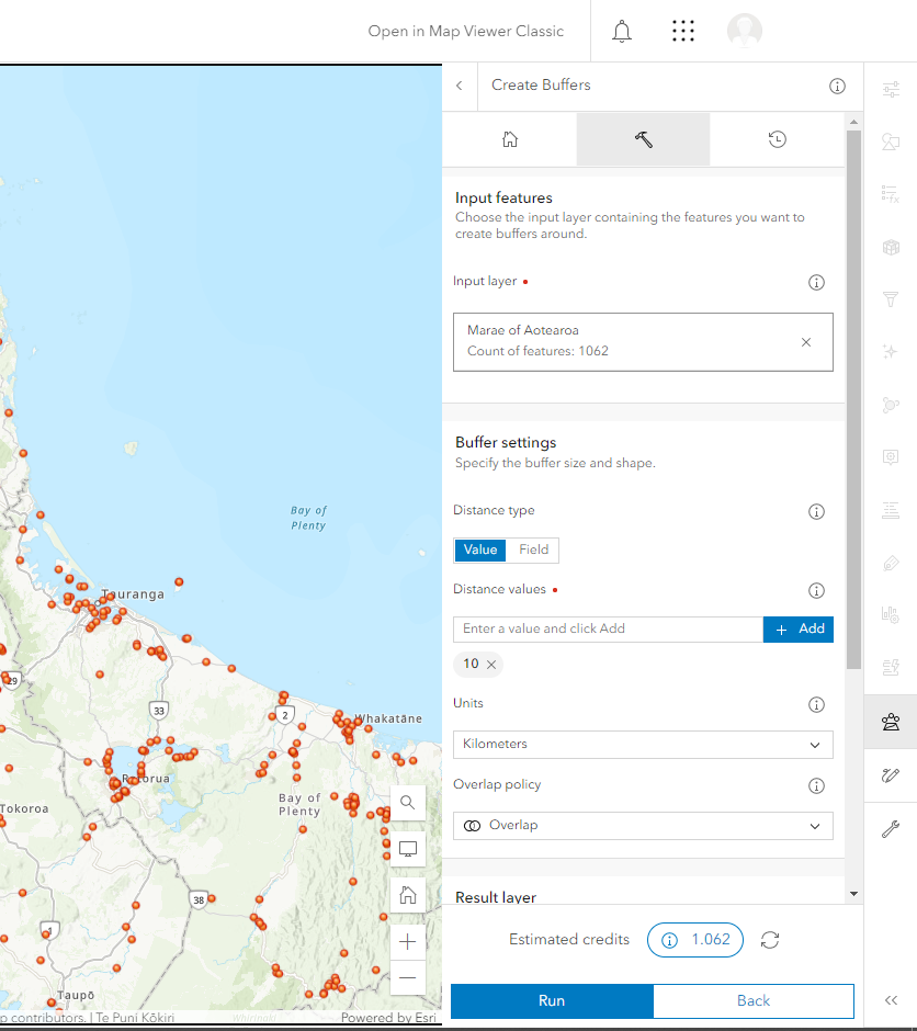
    Example: The Buffer Tool was used to create a 10km Buffer of each Marae in New Zealand (Data by Te Puni Kōkiri). It is estimated that 1.062 credits will be used to perform this analysis for all Marae across New Zealand.

    ArcGIS Online interface of Marae points in the North Island while using the Buffer Tool

    If you would like to reduce credit usage for a specific tool, you can limit the extent of your analysis to the map extent on your screen. This can be done using the display extent option in the environment settings of the buffer tool.

    ArcGIS Online Administrator – the February 2023 ArcGIS Online release does not allow you to change the default analysis extent globally to be the display extent.

    Estimating credit usage for storage

    As of April 2023, the feature storage charge cost is 2.4 credits per 10 MB stored per month and is calculated hourly.

    You can check the latest information about credit usage costs at the Esri ArcGIS Online site under ‘Credits by capability.’

    An ArcGIS Online Administrator can estimate the use of credits for storing features.

    Estimation Methodology

    As an Administrator, this methodology could help determine the number of credits used to store certain files.

    Example: This ArcGIS Online subscription has about 41.47 GB of feature storage. However, the cost of credits changes each day in the months of January and February in the new year.

    • Convert the Gigabyte (GB) to Megabyte (MB). Remember that 1GB = 1024 MB

    This equates to ~42465 MB

    • Calculate 2.4 credits per 10MB Stored each month.

    Divide the total of Megabyte by 10 = 4246.5

    • Multiplied by 2.4 credits per month for feature storage.

    This would be about 10,191.6 credits per month.

    • Results of Credit usage in months with different number of days

    Divide the total amount of credits per month to the number of days in the month.

    • January (31 days) = ~328 credits per day
    • February (28 days) = ~363 credits per day

    Credits are charged at a monthly rate; this means that the cost of credits differs each month. Therefore, the number of days per month impacts the cost of credits, even though the data size remains the same.

    Other resources

    Esri has additional resources available to explain ArcGIS Online credits.

    ArcGIS Online Credits – Storage (Video)
    Esri ArcGIS Online Credits (Web)
    Understanding credits (Help Page)

    If you need further assistance with understanding ArcGIS Online credits and their use, please contact your Eagle Technology Account Manager.

  • New Zealand Esri Young Scholar Award 2023 – Winner

    New Zealand Esri Young Scholar Award 2023 – Winner

    The Esri Young Scholar Award is about recognising the very best GIS students around the globe. Every year, Esri’s global partners nominate at least 25 university students for excellence in relation to a GIS project. These projects include comprehensive research papers, software development, impactful maps, and apps that promote education, conservation, disaster response, and urban planning.

    As the winner of the 2023 New Zealand Esri Young Scholar Award, Rachel Lawson, recent graduate of the University of Auckland, will be winging her way to San Diego to attend the Esri Education Summit and Esri User Conference in July 2023.

    Rachel’s award-winning project “Measuring disruption to human mobility and exposure to air pollution following the New Zealand International Convention Centre Fire” identified disruptions to movement corridors, exposure to smoke / air pollution, and emergency and citizen response during and after the event in Auckland, New Zealand in 2019. The judges were particularly impressed with the innovative use of ArcGIS to map social media posts.

    At Esri User Conference 2023 Rachel will get to display her project poster in the Map Gallery, in front of thousands of worldwide ArcGIS users and to meet Jack Dangermond in person at the Special Achievement Award Ceremony.

    We will make Rachel’s poster available for you to view post Esri User Conference. Hopefully, we will also be able to hear Rachel’s reflections on the summit and conference once she returns.

    The judges would like to highly commend Dylan Pollard, from the University of Otago, as the runner up for the New Zealand Esri Young Scholar Award 2023. Dylan’s project looked at the use of GIS in pest management in West Harbour, Dunedin. As runner up to this award Dylan will receive a complimentary registration to the New Zealand Esri User Conference in Auckland 2023.

    Thank you to all the other young scholars who applied for the New Zealand Esri Young Scholar Award in 2023. Your submissions were of the highest standard and made the judge’s job in choosing the best project very difficult.

  • LocalMaps 3.x (Beta)

    LocalMaps 3.x (Beta)

    It’s here! We are very excited to share that the new LocalMaps Viewer 3.x in Experience Builder is available in Beta.

    This Beta release is ready for you to explore and apply in your own organisations and is a good chance to see where the future of LocalMaps is headed. It’s been a long time coming and rest assured this is only the start – 2023 is going to be a pretty great year for LocalMappers all around!

    Now, where do we start…

    What’s New in the Viewer (well…everything)

    It’s a very fresh restart for the LocalMaps Viewer – leveraging Esri’s Experience Builder, you can make the most of the modern technology that underpins this application. New JS API v2 benefits you can make the most of include:

    • Fast loading – useful for rendering district plan/property layers
    • Lazy loading – for widget and asset-images
    • Search performance optimization

    And then there are the widgets. As we have mentioned, we have prioritised the most used tools to pull into this beta. This will give you a taste of what’s coming as well as let you test out your own key workflows and provide you the opportunity to give feedback towards the ongoing development of LocalMaps.

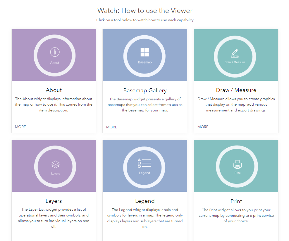
    Widgets Available:

    But nothing is better than giving it a go yourself, so take a look at the Eagle LocalMaps Demo site.

    LocalMaps NZ Resource Centre

    We know 3.x is a bit to take in and with our 2023 plans, we want to make sure you have all the info you need in one place. The new LocalMaps NZ Resource Centre has been created just for that – to give you all you need related to LocalMaps 3.x.


    From key features, use cases, and useful how-to videos, this site is a one-stop shop you should definitely bookmark. Of course, our trusty Geonet Page is still your go-to location for ideas and voting on what’s coming.

    What’s coming up next?

    So, as you can see, there are a few tools still yet to be included in 3.x. Our development focus now is to ensure we can provide all functionality you have in v2.x and make that available (and improved based on the ideas you have submitted to you) in v3.1.

    In the next few months, we will be building new and improved 3.x widgets for Add Data, Attribute Table, Bookmark, Elevation Profile, Save, Select, Share, Splash, and Zoom to Point. As these tools require in some cases a configuration element and backend, therefore the LM administration app is also in progress. Watch this space (and the What’s New page) for snippets as we go!

    Getting started with 3.x

    To get LocalMaps 3.x. Viewer, the first thing is to check out the technical requirements. The good news is, it is not much different than the requirements you have already met for v2.3.2. To learn more about implementation, contact your Eagle Technology Account Manager.

    As this is in Beta, your feedback is more valuable than ever – so if you have ideas, thoughts, questions, or comments of course, reach out to us at localmapssupport@eagle.co.nz or pop your ideas on our page here.

    Let us know what you think.

    The Eagle Technology LocalMaps Team

  • LM Viewer 3.x (beta) – Release Info and sneak peek

    LM Viewer 3.x (beta) – Release Info and sneak peek

    2023 is here and very soon, a new, modern, and refreshed LocalMaps Viewer will be too. Here are a few sneak peeks/features of the Viewer which will be available from Feb 9th, 2023.

    While we had aimed to release a BETA of the Experience Builder LocalMaps 3.x Viewer in 2022, we realise that many organisations likely would only be looking to get their hands onto the new viewer in the New Year.

    Below are a few sneak peeks/features info on the Viewer which will be available from Feb 9th 2023. As we have mentioned in a few coms and presentations around the viewer, we have focused on the most important/well-used components for our first beta release. So, while not ALL features or widgets are in there just yet, rest assured we have ticked off many requests to tide you over while we finish off the remaining widgets and crack into the admin UI for Version 3.1.   

    So here we go – some of our fav new features of the Viewer 3.x (Beta).

    JSAPI v4 Improvements including:

    • Fast loading – useful for rendering of district plan/property layers
    • Lazy loading – for widget and asset-images
    • Search performance optimization

    NEW Draw / Measure (and…cue applause!)

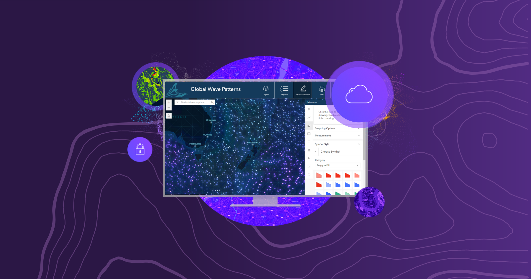
    • Taking inspiration from the Map Viewer Sketch capabilities, the new Draw / Measure has a fresh UI, taking in many enhancements from you all and designed to take you intuitively through annotation workflows.

    • Widget UI Improvements – Across the LocalMaps widgets, we have leveraged a combination of Esri’s Calcite Design Language & Esri’s Experience Builder team’s own UI components to develop a new look and feel in the Layers, Legend, and Print tools.
    • General Usability improvements e.g.Icon highlights for open widgets.

    That is just a little taste of the Viewer 3.x Beta – coming to you very soon! Keep an eye out here or on the LocalMaps Community page for more updates and how to get your hands on this next-gen experience.

    Nga Mihi,

    The Eagle Technology LocalMaps Team

  • Accessing Esri Academy eLearning

    Accessing Esri Academy eLearning

    If you would like to learn about a workflow or a component of the ArcGIS System at your own pace, eLearning from the Esri Academy is the place for you. 

    What is the Esri Academy?

    The Esri Academy is where you can access eLearning resources, created by Esri, to help you keep up with the rapidly changing geospatial world and to build the skills and expertise you need to reach your geospatial goals.

    The Esri Academy is sometimes referred to as the Esri Training website.

    eLearning Types

    There is a plethora of types of eLearning on the Esri Academy. Each type of eLearning in defined below:

    • MOOCs – Massive, open, online courses. Esri MOOCs range in length from four to six weeks and require an investment of two-three hours of study per week. A new set of materials is released each week for you to work through. Esri MOOCs have been designed to help expand horizons and advance geospatial careers.
    • Story Maps – Story Maps referenced on the Esri Academy combine authoritative maps with narrative text, images and multimedia content to enable you to learn about a specific topic or product in the ArcGIS System.
    • Training Seminars – Live and recorded video presentations with software demonstration by Esri subject matter experts. Eagle Technology also offers Training Seminars under the guise of our GIS Webinar Series. For a list of upcoming Eagle Technology Webinars visit https://bit.ly/3iNJiq5.
    • Tutorials – tutorials provide step by step instruction on how to complete a task or learn a workflow, they tend to cover some of the newer technology that Esri has recently released. Most tutorials are under an hour in length.
    • Videos – training and educational videos from Esri and industry experts
    • Web Courses – interactive self-paced courses with activities and hands-on exercises. Web courses are more in-depth than tutorials and therefore tend to take longer to complete.

    To access all Esri Academy eLearning content visit www.esri.com/training/Bookmark/PKZLC4PPYJ

    How do you get access to all the eLearning on the Esri Academy?

    To access any of the eLearning resources on the Esri Academy you need to login. Therefore, you need to have an Esri username and password. This may be an Esri public account, or a username connected to the organisation that you work for (this may be your ArcGIS Online username). The type of account you have will determine the level of access to eLearning resources you have.

    An Esri public account only gives you access to the eLearning resources  that are marked as ‘Free’. To access eLearning resource marked with the words ‘Requires Maintenance’, you need to have a username connected to the organisation you work for. This organisation also needs to pay Esri fees via Eagle Technology to access ArcGIS products and therefore to gain access to these resources. To connect an Esri public account to your organisation you need to have a chat to your organisation’s GIS Administrator to find out who can connect your account.

    Happy learning smiley

    By the way, if you are wanting to learn via instructor-led training instead of eLearning resources and are located in New Zealand or the South Pacific please visit Eagle Technology’s learn page for a list of the instructor-led courses we offer https://www.eagle.co.nz/learn/course-catalogue

    Information for GIS Administrators

    Your organisation can give employees access to all Esri Academy resources in one of two ways:

    • Through an Esri access enabled ArcGIS Online username
    • Via an Esri public account linked to your organisation’s My Esri account

    To enable Esri access on an ArcGIS Online username follow the instructions at https://bit.ly/3QOGhlW. With Esri access enabled, when someone logs into Esri Academy with their ArcGIS Online username, they will automatically gain access to all eLearning resources.

    If you get asked to connect an Esri public account username to your organisation for eLearning access, you can do this on the My Esri website. To make this connection using the below process you need to be an Administrator on the My Esri website for your organisation.

    The process of connecting an Esri public account to your organisation to enable Esri Academy eLearning materials is as follows:

    1. Login into My Esri
    2. Click Users > Invite Users
    3. Enter the email address for the person requesting access to the eLearning resources, you can give multiple people access to the eLearning resources by uploading a CVS or XLXS file of email addresses, you can invite up to 1000 people at a time
    4. Click Validate, invalid emails will be flagged
    5. Once all email addresses are valid, click Next
    6. Specify Access e-Learning permission (turn off other access at this stage if appropriate), click Next
    7. Add appropriate text to the invite that will be sent to the people you are inviting to access eLearning resources
    8. Send the invite(s)
    9. The person who receives the invite needs to click the link in the email and login with their public Esri account. Once they are logged in, your employee will be connected to your organisation in MyEsri and will have full access to all eLearning on the Esri Academy

    If you are unsure whether you should enable access to Esri Academy eLearning resources via My Esri or ArcGIS Online, read this article to help plan your approach.

    If you would like some assistance with setting up access to Esri Academy eLearning resources, please contact gistraining@eagle.co.nz

  • Careers in GIS

    Careers in GIS

    At the New Zealand Esri User Conference 2022 during the Growing GIS People session, we launched a new industry initiative entitled Careers in GIS. The central idea for this initiative is to enable the community to have a Hub that sells GIS as a Career to people who fall into four main personas:

    • School students – targeting juniors at high school who are trying to make their subject choices but also seniors who are trying to decide what courses to take at a tertiary provider
    • Graduates – targeting early talent, people just finishing their tertiary education study and looking to launch into the workforce, could include links to organisations’ intern and graduate programmes.
    • Career Changers – information for people who are looking to change their career after being in the workforce for some time
    • Volunteers – people looking to get some work experience in GIS or just wanting to make a difference in their communities using GIS, this information might include links to volunteer organisations that use GIS e.g. GIC

    The personas would be prominently displayed on the front page of the hub and each persona would have a subpage with content to help that persona progress. For example, the school student sub page might have some of the following:

    • Videos of people talking about what they do in their job and how they use GIS as part of that job
    • Recommendations on what subjects to study at school and tertiary education providers
    • Links to tertiary education providers who have GIS papers or programmes

    The Careers in GIS hub would be hosted by Eagle Technology, but we envision the NZ Esri User Community would be contributing to the content of the hub.

    Call to action – at NZEUC 2022 we asked people to submit their name via the following survey123 form and add a comment around how they would like to help with this initiative. We are now extending this call to action to the wider NZ Esri User Community. So please submit your details and ideas about how you can contribute here

  • Urban Digital Twin and NPS-UD

    Urban Digital Twin and NPS-UD

    In order to ensure New Zealand’s towns and cities are well-functioning urban environments that meet the changing needs of our diverse communities, the National Policy Statement on Urban Development (NPS-UD) was announced in July 2020. It introduces a new urban planning approach along with new objectives and policies and is designed to support well-functioning cities which meet the needs of communities into the future. It requires city councils across New Zealand to make changes in their district plans to enable higher density, more housing supply, better access to public transport and overall, to ensure a more efficient and sustainable urban environment.
    As you would expect, a core part of this work relates to spatial data being captured, stored, analysed, and visualised and here at Eagle Technology, we have been working with city councils across New Zealand to develop workflows to support this initiative.
    These workflows allow councils to incorporate NPS-UD objectives and policies leveraging Digital Twin and Esri ArcGIS smart city planning tools.

    Eagle’s Omid Khazaeian has created an ArcGIS StoryMap which introduces Esri ArcGIS Urban as a new smart city planning tool and elaborates on some of its key use cases for NPS-UD in New Zealand context.
    We are continuously developing and updating content related to this this exciting space and are very keen to have feedback from this community.

  • NZ Raster Basemaps (Classic) Are Moving to Mature Support

    NZ Raster Basemaps (Classic) Are Moving to Mature Support

    On 5 December 2022, the remaining New Zealand “Classic” Raster Basemaps will be moving to mature support. When basemaps are moved to mature support it means that the items will still be available, but they will no longer receive updates. For this reason, we strongly recommend updating your maps, apps and basemap gallery to use the latest NZ Raster and Vector Basemaps.

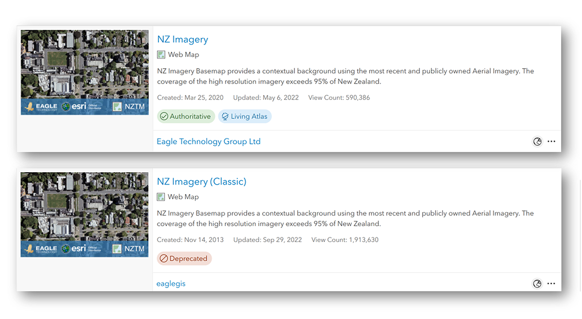
    For each NZ Raster Basemap there are two versions available:

    Why two versions of the same basemaps?

    Due to basemap switching compatibility issues with applications such as the 3D Scene Viewer, and Web App Builder we have made our basemap tiling scheme’s uniform and consistent across all NZ raster basemaps and the NZ vector basemaps. Not only will be able to easily switch between and overlay the NZ basemaps, but you can also zoom deeper as the current raster basemaps all allow zooming in to 1:70.  

    Which NZ Raster Basemaps are already in mature support?

    The following raster basemaps moved to mature support at the start of 2022:

    Both the classic and current version are not receiving any more updates. We recommend migrating to the equivalent Vector Basemap. The vector basemaps can be found in ArcGIS Online, ArcGIS Living Atlas and in this group. More information on the NZ Vector Basemaps can be found in this StoryMap.

    Which NZ Raster Basemaps will move to mature support, and which won’t?

    The following raster basemaps will move to mature support from 5 December 2022:

    The current versions of these maps will not be moving to mature support and will continue to be updated.

    If you are using one of these Classic basemaps we encourage you to migrate to the current versions of these maps, that won’t be moving to mature support:

    How can I tell which version of basemap I’m using?

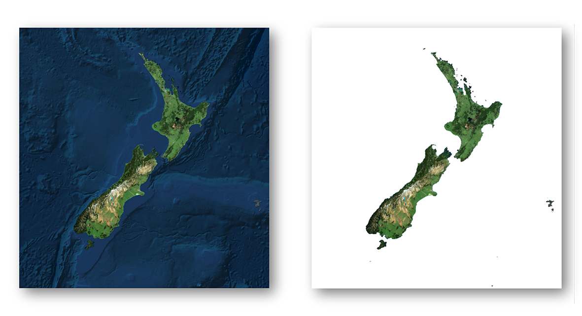
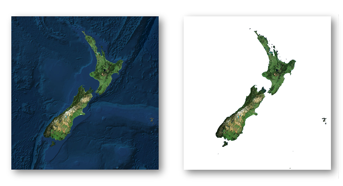
    You can easily identify which NZ Imagery Basemap you’re using by whether blue bathymetry is present. If your basemap is floating in white space, you are using the Classic version and you should migrate. Whereas, if you see blue bathymetry around New Zealand, you’re using the current version.

    For other basemaps there are a few ways you can identify if you are using the Classic version. In the web map you can open the properties of the basemap and check if it is using the services1.arcgisonline.co.nz URL.

    While in the app, you can also open the Network Tab in your Browser’s Developer Tools. If you pan the map with the Network Tab open, you can check if any requests are made to services.arcgisonline.co.nz. You can add services.arcgisonline.co.nz to the filter to more easily identify this. If there are requests made to that URL then the app uses basemap in mature support.

    Migrating

    Migrating from the Classic basemaps to the current versions or a vector basemap will in most cases be as simple as switching out the old one for the new one in the Web Map or App. There are situations where some extra care is required. In any case, testing the new basemap before switching is recommended. Here are a few cases where extra care is needed. There may be other situations where extra effort may be needed.

    Your app uses the Scale/Zoom Level ID to zoom to a specific scale or uses url-parameters to zoom to a specific scale

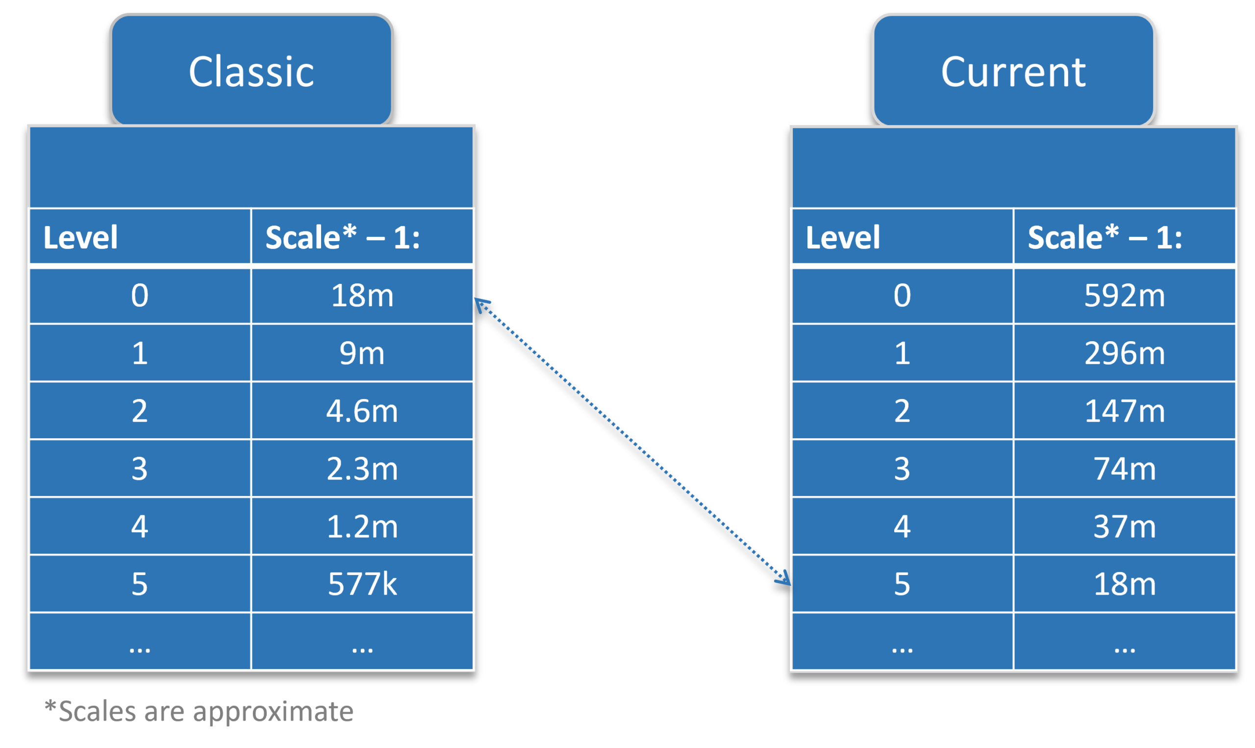
    With the new tiling scheme for the current raster basemaps 5 new small-scale levels have been added. This means that the scale level IDs represent a different scale. For example, scale level ID 10 in the Classic basemaps equals scale 1: 18,055.954822. In the current raster basemaps scale level id 10 equals scale 1:577,790.554289. To maintain the same scale level, you need to update the app to zoom to scale level ID 15.

    Your ArcGIS 3D Scene or ArcGIS 3D application uses other tiled layers on top of the basemap

    3D Scenes and applications are stricter when it comes to using different tiling schemes. When your 3D scene or app has a tiled layer (raster or vector) on top of one of the Classic basemaps you will most likely need to re-tile that layer using the same tiling scheme as the current NZ Basemaps. The tiling scheme can be found here.

    Update your basemap gallery

    If your organization uses a custom basemap gallery, we recommend you remove the raster basemaps that are in mature support and replace them with either the vector basemaps or the current basemaps. As this basemap gallery can be used in other locations than the Map Viewers, for example in ArcGIS Web AppBuilder applications, make sure to test if this change has any impact on your current applications, especially when your custom basemap gallery has a combination of Eagle Technology basemaps and custom basemaps that are cached using one of the Classic tiling schemes.

    When updating your basemap gallery group, make sure to add the Web Map to the group and not the layer.

    To find out how to update your basemap gallery, see this blog post:

    ArcGIS Living Atlas

    The basemaps that are in mature support or are moving to mature support are no longer available in Living Atlas. They have also received the “Deprecated” tag. This ensures they are prioritized less in search results. You can find all the Classic basemap items in this group.

    If you have any questions about this move, please get in touch with your Eagle Technolgy representatve or contact us at livingatlas@eagle.co.nz.